Oudie 3
42
© 2003 - 2013 ... Naviter d.o.o.
North, East, South and West Up, will rotate the map so, that the selected orientation is towards the top
of the screen.
Goal Up will put the direction of the Selected Goto Waypoint to the top of the screen. Track Up will put
the direction of the current track towards the top of the screen.
When panning the map freely, the arrow gets a caption "Pan mode". Tapping once on this symbol
returns the view back to the glider and original map orientation.
See also:
Map orientation
3.4
Wind vector
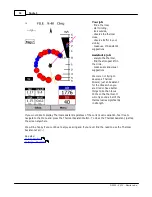
The wind vector gives you a graphical and textual orientation about the wind at current height. It is
measured in different ways depending on what data is available to Oudie 3.
A tap on the Wind symbol will open the Wind dialog. You can also access it through
Menu > Wind
3.5
Vector map
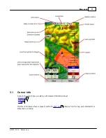
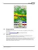
Oudie 3 uses the CIT maps to display terrain and topographic features. These are the same maps also
used in the desktop version of SeeYou. Maps for the whole world are preloaded on Oudie 3 already. Just
turn it on and you will have a map.
Map preferences can be setup through the
Setup Map
dialog.
54
71
74
Summary of Contents for Oudie 3
Page 1: ...2003 2013 Naviter d o o Oudie 3 Help Last modified 26 7 2013 for version 4 50...
Page 5: ...Part I...
Page 8: ...Part II...
Page 30: ...Oudie 3 26 2003 2013 Naviter d o o...
Page 35: ...Getting started 31 2003 2013 Naviter d o o...
Page 39: ...Part III...
Page 44: ...Oudie 3 40 2003 2013 Naviter d o o...
Page 49: ...Part IV...
Page 51: ...Part V...
Page 53: ...Part VI...
Page 77: ...Part VII...
Page 110: ...Oudie 3 106 2003 2013 Naviter d o o See also Using vario Volume altitude 12 109...
Page 111: ...Part VIII...
Page 118: ...Oudie 3 114 2003 2013 Naviter d o o...
Page 120: ...Oudie 3 116 2003 2013 Naviter d o o...
Page 121: ...Part IX...
Page 123: ...Part X...
Page 126: ...Part XI...
Page 128: ...Part XII...
Page 130: ...Part XIII...

