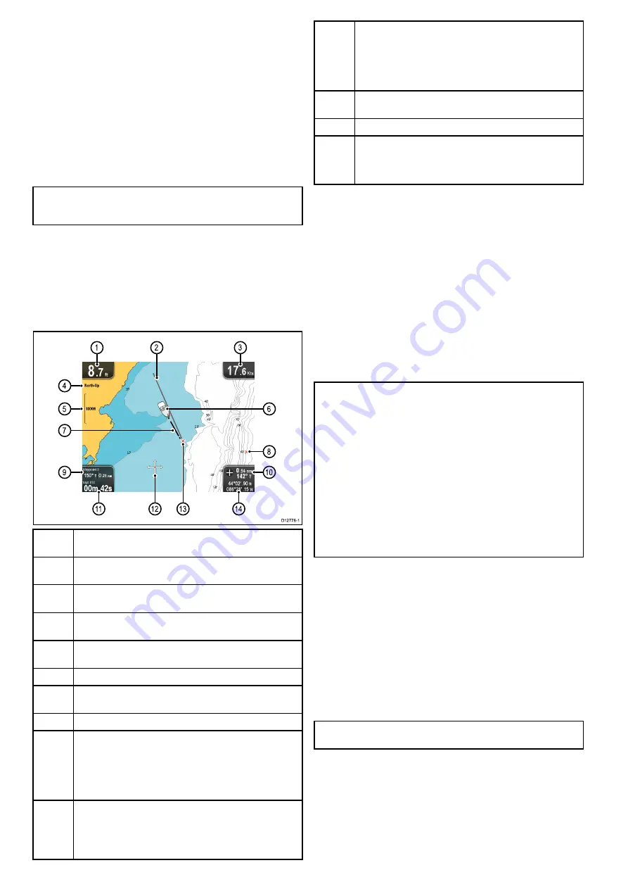
8.1 Chart application overview
The chart application provides an electronic chart with navigation
features. It uses 2D perspective and provides a variety of
cartographic information regarding your surroundings and
charted objects.
Typical uses for the chart application include:
• Monitor your vessel location and course over ground (COG).
• Interpret your surroundings.
• Navigate using waypoints.
• Keep track and record your course.
• View information for charted objects.
Note:
To obtain full chart details, you must have a cartography
chart card for the appropriate geographic area inserted into
the card reader.
You can also customize the chart application as follows:
• Control the level of detail displayed on-screen.
• Change the way the chart is drawn in relation to your vessel
position and the direction of travel.
• Display the COG vector.
• Change the depth at which the deep water contour changes
color.
D12778-1
1
1
1
2
1
3
1
4
4
5
9
7
8
6
1
0
1
2
3
1
Depth
— Current water depth below vessel (shown in selected
system units).
2
Navigation origin line
— During navigation, shows a solid line
from the starting point to the target waypoint.
3
Speed
— Current vessel speed (shown in selected system
units).
4
Orientation
— States the orientation mode that the chart is
using (North-up, or Course-up).
5
Range
— Chart scale indicator (shown in selected system
units).
6
Vessel symbol
— Shows your current position.
7
Vessel position line
— During navigation, shows a dotted line
from the vessel’s current position to the target waypoint.
8
Waypoint
— Inactive.
9
Bearing and distance to Waypoint
— During active navigation
displays the distance and bearing to the target waypoint (shown
in selected system units).
Water temperature
— When not in active navigation current
water temperature is displayed (shown in selected system
units).
10
Bearing
— In motion mode the vessel’s current COG bearing
is displayed.
Bearing and distance
— In cursor mode the distance and
bearing to the cursor’s location is displayed (shown in selected
system units).
11
Waypoint TTG
— During active navigation the estimated ‘time
to go’ to the target waypoint based on your current speed is
displayed.
Water temperature
— When not in active navigation current
water temperature is displayed (shown in selected system
units).
12
Cursor
— Used to select chart objects and move around the
chart area.
13
Target waypoint
— Current target waypoint.
14
Vessel coordinates
— In motion mode the current vessel
coordinates are displayed.
Cursor coordinates
— In cursor mode the coordinates of the
cursor’s location is displayed.
Chart cards overview
Chart cards provide additional cartographic information.
Obtain detailed cartographic information for the area that
you navigate using Navionics® chart cards. To check the
current availability of Navionics chart card types, please
visit
or
. The amount of
cartographic detail shown varies for different areas and for
different scales. The chart scale in use is indicated by the
on-screen chart scale, the number represents the distance the
line represents in nautical miles across the chart.
You can remove and insert chart cards while a chart is displayed
provided that you follow the correct procedure. The chart
information is retained on-screen until the chart application
redraws the screen; for example, when you pan outside the
current area, or change the chart scale.
Caution: Care of chart and memory
cards
To avoid irreparable damage to and / or loss of data
from chart and memory cards:
• Ensure that chart and memory cards are fitted
the correct way around. DO NOT try to force a
card into position.
• DO NOT save data (waypoints, tracks, and
so on) to a chart card, as the charts may be
overwritten.
• DO NOT use a metallic instrument such as a
screwdriver or pliers to insert or remove a chart
or memory card.
Chart compatibility
Your display is supplied with a base map and depending on unit
a Navionics chart card. You may also purchase Navionics chart
cards to get enhanced chart details and additional chart features.
Your display is compatible with the following Navionics chart
cards:
• Silver
• Gold
• Gold+
• Hotmaps
Note:
Refer to the Raymarine website (
)
for the latest list of supported chart cards.
46
Dragonfly
Summary of Contents for E70085 Dragonfly
Page 2: ......
Page 4: ......
Page 10: ...10 Dragonfly ...
Page 14: ...14 Dragonfly ...
Page 18: ...18 Dragonfly ...
Page 28: ...28 Dragonfly ...
Page 32: ...32 Dragonfly ...
Page 52: ...52 Dragonfly ...
Page 70: ...70 Dragonfly ...
Page 78: ...78 Dragonfly ...
Page 82: ...82 Dragonfly ...
Page 95: ......
Page 96: ...www raymarine com ...


