9.12 High resolution bathymetry
The
High Res Bathy
setting is available when using
Jeppesen charts and switches the display to view
high resolution bathymetry data.
Note:
With
High Res Bathy
switched on the
cartography is not suitable for navigation.
Off
On
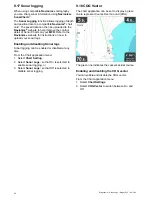
Switching High Res Bathy on and off
If supported by your cartography type, the chart can
be switched to display high resolution bathymetry
data.
From the Chart application menu:
1. Select
Chart Settings
.
2. Select
High Res Bathy:
so that On is selected to
display high resolution bathymetry data, or
3. Select
High Res Bathy:
so that Off is selected to
turn off high resolution bathymetry data.
9.13 Chart orientation
The orientation of a chart refers to the relationship
between the chart and the direction that you are
travelling in.
The mode you choose applies to all chart views, and
is restored at power up.
The following options are available:
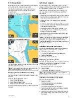
North Up
In
North Up
mode, the
Chart Orientation
is
fixed with true north pointing up (this is the usual
orientation for nautical charts). As your heading
changes the vessel symbol rotates accordingly. This
is the default orientation for the Chart application.
Course Up
In
Course Up
mode, during active navigation,
the Chart application displays the vessel’s current
destination waypoint directly up. As your COG
changes, the boat symbol moves accordingly. If you
select a new course, the picture will reset to display
the new course upwards.
If COG data becomes unavailable
Course Up
mode
is suspended and the Chart application will set COG
to 0°.
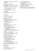
Setting the chart orientation
From the chart application menu:
1. Select
Chart settings
.
Chart application
87


