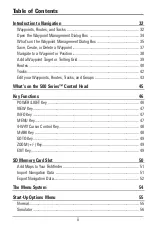
Table of Contents
Zoom Width............................................................................................................ 88
455 kHz Sensitivity
(Advanced, Down Imaging™ only)
.............................................. 89
Depth Lines
(Advanced)
.......................................................................................... 89
Noise Filter
(Advanced)
............................................................................................ 89
Max Depth
(Advanced)
............................................................................................ 90
Water Type
(Advanced)
............................................................................................ 90
Digital Depth Source
(Advanced, optional-purchase transducers only)
........................ 91
DI Pings
(Advanced, Down Imaging™ View and Chart/Down Combo View only)
............ 91
Imaging Palette
(Down Imaging™ Views only)
.......................................................... 92
Navigation Menu Tab
93
Current Track .......................................................................................................... 94
Waypoints, Routes, Tracks
(Waypoint Management Dialog Box)
.............................. 94
Waypoint Settings.................................................................................................. 95
Saved Tracks Defaults............................................................................................ 95
Chart Orientation.................................................................................................... 96
Casting Rings
(Advanced)
........................................................................................ 96
Lat/Lon Grid............................................................................................................ 96
Chart Select
(SD card in slot)
.................................................................................... 96
North Reference .................................................................................................... 96
Waypoint Proximity Flags
(Advanced)
.................................................................... 97
Waypoint Decluttering
(Advanced)
.......................................................................... 97
Grid Rotation .......................................................................................................... 98
Trackpoint Interval.................................................................................................. 98
Track Min Distance
(Advanced)
.............................................................................. 98
Map Datum
(Advanced)
.......................................................................................... 99
Set Simulation Position
(Advanced)
........................................................................ 99
Set Map Offset
(Advanced)
...................................................................................... 99
Clear Map Offset
(Advanced)
................................................................................ 100
North-Up Indicator .............................................................................................. 100
Course Projection Line ........................................................................................ 100
Chart Detail Level ................................................................................................ 101
v

