


GNS 530(A) Pilot’s Guide and Reference
190-00181-00 Rev. G
13-1
SECTION 13
TAWS
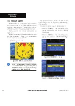
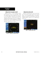
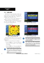
SECTION 13: TAWS
NOTE: GNS 530 units may* display either a
TERRAIN Page or a TAWS Page, (but not both)
depending upon the installed hardware and
configuration.
* Some earlier units are not equipped to support the
/,, Ê>`ÉÀÊ/7-ÊvÕVÌ>ÌÞ]ÊÃÊÌ
iÀivÀiÊÜÊÌÊ
>ÛiÊ>Ê/,, ÊÀÊ/7-Ê«>}iÊ>Û>>Li°
13.1 INTRODUCTION
/7-Ê /iÀÀ>Ê Ü>ÀiiÃÃÊ >`Ê 7>À}Ê -ÞÃÌi®Ê ÃÊ
a feature to increase situational awareness and aid in
Ài`ÕV}Ê VÌÀi`Ê y}
ÌÊ ÌÊ ÌiÀÀ>Ê /®°Ê Ê /7-Ê
Ã>ÌÃwiÃÊ/-"£x£LÊ>ÃÃÊ ÊÀiµÕÀiiÌÃÊvÀÊViÀÌwV>Ì°ÊÊ
>ÃÃÊ Ê/7-ÊÃÊÀiµÕÀi`ÊvÀÊ>Ê*>ÀÌÊ£Ê>ÀVÀ>vÌÊ«iÀ>ÌÃÊ
ÜÌ
ÊÃÝÊÀÊÀiÊ«>ÃÃi}iÀÊÃi>ÌÃÊ>`ÊvÀÊ*>ÀÌÊ£ÎxÊÌÕÀLiÊ
>ÀVÀ>vÌÊ«iÀ>ÌÃÊÜÌ
ÊÃÝÊÌÊiÊ«>ÃÃi}iÀÊÃi>ÌÃÊ,Ê
*>ÀÌÃÊ£°ÓÓÎ]Ê£Îx°£x{®°
/7-Ê vÕVÌ>ÌÞÊ ÃÊ >Ê >Û>>LiÊ vi>ÌÕÀiÊ vÕ`Ê Ê
-ÊxÎäÊ/7-ÊÕÌÃÊÜÌ
Ê>ÊÃvÌÜ>ÀiÊÛiÀÃÊÈ°ä£ÊÀÊ
>LÛi]Ê>}ÊÜÌ
Ê>««À«À>ÌiÊ
>À`Ü>ÀiÊÕ«}À>`iðÊÊ/7-Ê
provides visual and aural annunciations when terrain and
obstacles are within the given altitude threshold from the
aircraft.
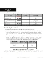
Operating Criteria
/7-ÊÀiµÕÀiÃÊÌ iÊvÜ}ÊÌÊ«iÀ>ÌiÊ«À«iÀÞ\Ê
Ê UÊÊ/ iÊÃÞÃÌiÊÕÃÌÊ >ÛiÊ>ÊÛ>`ÊÎÊ*-Ê«ÃÌÊ
solution.
Ê UÊÊ/ iÊÃÞÃÌiÊÕÃÌÊ >ÛiÊ>ÊÛ>`ÊÌiÀÀ>ÉLÃÌ>ViÉ
airport terrain database.
Limitations
NOTE: The data contained in the TAWS databases
comes from government agencies. Garmin
accurately processes and cross-validates the
data but cannot guarantee the accuracy and
completeness of the data.
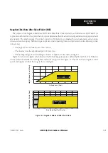
/7-Ê`ë>ÞÃÊÌiÀÀ>Ê>`ÊLÃÌÀÕVÌÃÊÀi>ÌÛiÊÌÊÌ iÊ
altitude of the aircraft. The displayed caution and warning
alerts are advisory in nature only. Individual obstructions
>ÞÊLiÊÃ ÜÊvÊ>Û>>LiÊÊÌ iÊ`>Ì>L>Ãi°ÊÊÜiÛiÀ]Ê>Ê
obstructions may not be available in the database and
data may be inaccurate. Never use this information for
navigation or to maneuver to avoid obstacles.
Terrain information is based on terrain elevation
information in a database that may contain inaccuracies.
Terrain information should be used as an aid to situational
awareness. Never use it for navigation or to maneuver to
avoid terrain.
/7-ÊÕÃiÃÊÌiÀÀ>Ê>`ÊLÃÌ>ViÊvÀ>ÌÊÃÕ««i`Ê
by government sources. The data undergoes verification
LÞÊ>ÀÊÌÊVwÀÊ>VVÕÀ>VÞÊvÊÌ
iÊVÌiÌ]Ê«iÀÊ/-"
£x£L°ÊÊÜiÛiÀ]ÊÌ
iÊ`ë>Þi`ÊvÀ>ÌÊÃ
Õ`ÊiÛiÀÊ
be understood as being all-inclusive.
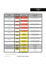
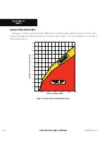
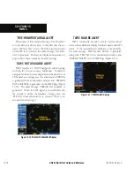
TAWS Alerting
/7-ÊÕÃiÃÊvÀ>ÌÊ«ÀÛ`i`ÊvÀÊÌ iÊ*-ÊÀiViÛiÀÊ
ÌÊ«ÀÛ`iÊ>Ê
ÀâÌ>Ê«ÃÌÊ>`Ê>ÌÌÕ`i°ÊÊ*-Ê>ÌÌÕ`iÊ
ÃÊ `iÀÛi`Ê vÀÊ Ã>ÌiÌiÊ i>ÃÕÀiiÌÃ°Ê Ê *-Ê >ÌÌÕ`iÊ ÃÊ
VÛiÀÌi`ÊÌÊ>Êi>ÊÃi>ÊiÛiÊ-®L>Ãi`Ê>ÌÌÕ`iÊ*-
-Ê >ÌÌÕ`i®Ê >`Ê ÃÊ ÕÃi`Ê ÌÊ `iÌiÀiÊ /7-Ê >iÀÌðÊÊ
*--Ê >ÌÌÕ`iÊ >VVÕÀ>VÞÊ ÃÊ >vviVÌi`Ê LÞÊ v>VÌÀÃÊ ÃÕV
Ê
as satellite geometry, but it is not subject to variations in
pressure and temperature that normally affect pressure
>ÌÌÕ`iÊ`iÛViðÊÊ*--Ê>ÌÌÕ`iÊ`iÃÊÌÊÀiµÕÀiÊV>Ê
>ÌiÌiÀÊÃiÌÌ}ÃÊÌÊ`iÌiÀiÊ-Ê>ÌÌÕ`i°ÊÊ/
iÀivÀi]Ê
*-Ê>ÌÌÕ`iÊ«ÀÛ`iÃÊ>Ê
}
ÞÊ>VVÕÀ>ÌiÊ>`ÊÀi>LiÊ-Ê
altitude source to calculate terrain and obstacle alerts.
Summary of Contents for GNS 530
Page 1: ...GNS 530 A Pilot s Guide and Reference...
Page 2: ......
Page 10: ...GNS 530 A Pilot s Guide and Reference 190 00181 00 Rev G viii WARRANTY Blank Page...
Page 36: ...GNS 530 A Pilot s Guide and Reference 190 00181 00 Rev G 2 6 SECTION 2 COM Blank Page...
Page 116: ...GNS 530 A Pilot s Guide and Reference 190 00181 00 Rev G SECTION 6 PROCEDURES 6 34 Blank Page...
Page 142: ...GNS 530 A Pilot s Guide and Reference 190 00181 00 Rev G 7 26 SECTION 7 WPT PAGES Blank Page...
Page 190: ...GNS 530 A Pilot s Guide and Reference 190 00181 00 Rev G 10 30 SECTION 10 AUX PAGES Blank Page...
Page 280: ...GNS 530 A Pilot s Guide and Reference 190 00181 00 Rev G I 6 INDEX Blank Page...
Page 281: ......