


GNS 530(A) Pilot’s Guide and Reference
190-00181-00 Rev. G
10-20
SECTION 10
AUX PAGES
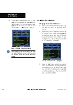
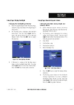
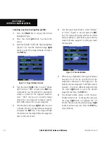
CDI Scale/Flight Phase:
RAIM Protection:
Auto (oceanic)
4.0 nm
±
5.0 nm or Auto (enroute)
2.0 nm
±
1.0 nm or Auto (terminal)
1.0 nm
±
0.3 nm or Auto (approach)
0.3 nm
Table 10-2 CDI Scales
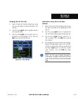
Ê Ê¼>Õ̽Ê-ÊÊÃiiVÌÊ>ÜÃÊÌ iÊ -ÊxÎäÊ
ÌÊ>ÕÌ>ÌV>ÞÊÃÜÌV
ÊÌ
iÊiÝÌiÀ>ÊÊvÀÊ
Ì
iÊ*-ÊÀiViÛiÀÊÌÊÌ
iÊ6"ÊÀiViÛiÀ]ÊÜ
iÊ
iÃÌ>LÃ
i`ÊÊÌ
iÊw>Ê>««À>V
ÊVÕÀÃiÊ-iVÌÊ
Ȱή°ÊÊ"À]ÊÃiiVÌʼ>Õ>½ÊÌÊ>Õ>ÞÊÃÜÌV
ÊÌ
iÊ
iÝÌiÀ>ÊÊViVÌ]Ê>ÃÊii`i`°
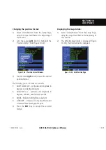
Ê Ê>ÀÀÛ>Ê>>À]Ê«ÀÛ`i`ÊÊÌ iÊÉ>ÀÃÊ
*>}i]Ê>ÞÊLiÊÃiÌÊÌÊÌvÞÊÌ iÊ«ÌÊÜÌ Ê>ÊiÃÃ>}iÊ
when the aircraft has reached a user-defined
`ÃÌ>ViÊÌÊÌ
iÊw>Ê`iÃÌ>ÌÊÌ
iÊ`ÀiVÌÌÊ
Ü>Þ«ÌÊÀÊÌ
iÊ>ÃÌÊÜ>Þ«ÌÊÊ>Êy}
ÌÊ«>®°ÊÊ
"ViÊÌ
iÊ>ÀVÀ>vÌÊ
>ÃÊÀi>V
i`ÊÌ
iÊÃiÌÊ`ÃÌ>ViÊÕ«Ê
ÌÊ°ÊÕÌî]Ê>ʼÀÀÛ>Ê>ÌÊQÜ>Þ«ÌR½ÊiÃÃ>}iÊ
is displayed.
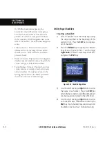
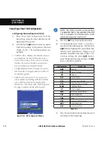
Ê / iÊÀë>ViÊ>ÀÃÊwi`ÃÊ>ÜÊÌ iÊ«ÌÊÌÊ
turn the controlled/special-use airspace message
alerts on or off. This does not affect the alerts
ÃÌi`ÊÊÌ iÊ i>ÀiÃÌÊÀë>ViÊ*>}iÊÀÊÌ iÊ
airspace boundaries depicted on the
>«Ê*>}i°ÊÊÌÊ
simply turns on/off the warning provided when
approaching or near an airspace.
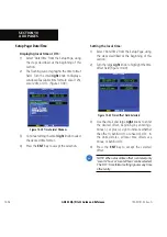
Ê>ÌÌÕ`iÊLÕvviÀÊÃÊ>ÃÊ«ÀÛ`i`ÊÜ V ʼiÝ«>`ýÊ
the vertical range above or below an airspace. For
iÝ>«i]ÊvÊÌ iÊLÕvviÀÊÃÊÃiÌÊ>ÌÊxääÊviiÌ]Ê>`ÊÌ iÊ>ÀVÀ>vÌÊ
is more than 500 feet above or below an airspace,
the pilot is not notified with an alert message; if
the aircraft is less than 500 feet above or below an
airspace and projected to enter it, the pilot is notified
ÜÌ Ê>Ê>iÀÌÊiÃÃ>}i°ÊÊ/ iÊ`iv>ÕÌÊÃÊÓääÊviiÌ°
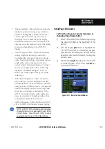
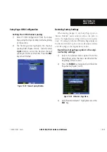
UÊ ¼1ÌÃÉ*Ã̽ÊÊÜÃÊÌ iÊ«ÌÊÌÊVw}ÕÀiÊ
the displayed data to standard or metric units of
measure. This setting applies to distance, speed,
>ÌÌÕ`i]ÊvÕi]Ê«ÀiÃÃÕÀi]Ê>`ÊÌi«iÀ>ÌÕÀi°ÊÊÃÊ
provides three
>}iÌVÊÛ>À>ÌÊ i>`}®Ê
«ÌÃ\Ê/ÀÕi]ÊÕÌ]ÊÀÊ1ÃiÀ`iwi`°ÊÊvʼÕ̽ÊÃÊ
selected, all track, course and heading information
is corrected to the magnetic variation computed
LÞÊÌ
iÊ*-ÊÀiViÛiÀ°ÊÊ/
iʼ/ÀÕi½ÊÃiÌÌ}ÊÀiviÀiViÃÊ
>ÊvÀ>ÌÊÌÊÌÀÕiÊÀÌ
]Ê>`ÊÌ
iʼ1ÃiÀ½ÊÃiÌÌ}Ê
corrects information to an user-entered value.
Configuration settings for position format are
also provided, and the map datum setting is
shown. The map datum used in the GNS 530
ÃÊ7-Ên{°ÊÊ ÌiÊÌ >ÌÊ>Ê>«Ê`>ÌÕÊÌ >ÌÊ`iÃÊ
not match the charts can result in significant
`vviÀiViÃÊÊ«ÃÌÊvÀ>Ì°ÊÊ7 iÊÕÃ}Ê
the paper charts for reference only, the GNS 530
still provides correct navigation guidance to the
waypoints contained in the database, regardless of
the datum differences.
UÊ ¼>ÌiÉ/i½ÊÊ*ÀÛ`iÃÊÃiÌÌ}ÃÊvÀÊÌiÊvÀ>ÌÊ
V>ÊÀÊ1/ÆÊ£ÓÊÀÊÓ{ ÕÀ®Ê>`ÊÌiÊvvÃiÌ°Ê
The time offset is used to define current local
Ìi°Ê1/Ê>ÃÊV>i`Ê/ÊÀÊ<ÕÕ®Ê
date
>`ÊÌiÊ>ÀiÊV>VÕ>Ìi`Ê`ÀiVÌÞÊvÀÊÌ iÊ*-ÊÊ
satellites’ signals and cannot be changed. To use
local time, simply designate the offset by adding
or subtracting the correct number of hours.
Summary of Contents for GNS 530
Page 1: ...GNS 530 A Pilot s Guide and Reference...
Page 2: ......
Page 10: ...GNS 530 A Pilot s Guide and Reference 190 00181 00 Rev G viii WARRANTY Blank Page...
Page 36: ...GNS 530 A Pilot s Guide and Reference 190 00181 00 Rev G 2 6 SECTION 2 COM Blank Page...
Page 116: ...GNS 530 A Pilot s Guide and Reference 190 00181 00 Rev G SECTION 6 PROCEDURES 6 34 Blank Page...
Page 142: ...GNS 530 A Pilot s Guide and Reference 190 00181 00 Rev G 7 26 SECTION 7 WPT PAGES Blank Page...
Page 190: ...GNS 530 A Pilot s Guide and Reference 190 00181 00 Rev G 10 30 SECTION 10 AUX PAGES Blank Page...
Page 280: ...GNS 530 A Pilot s Guide and Reference 190 00181 00 Rev G I 6 INDEX Blank Page...
Page 281: ......