


Garmin G900X Pilot’s Guide
190-00726-00 Rev. J
480
HAZARD AVOIDANCE
SY
STEM
O
VER
VIEW
FLIGHT
INSTRUMENTS
EIS
AUDIO P
ANEL
& CNS
FLIGHT
MANA
GEMENT
HAZARD
AV
OID
ANCE
AFCS
ADDITIONAL FEA
TURES
APPENDICES
INDEX
DISPLAYING TRAFFIC DATA
Traffic information can be displayed on the following maps:
• PFD Inset Map
• Navigation Map Page
• Traffic Map Page
• Trip Planning Page
• Nearest Pages
• Active Flight Plan Page
Traffic information is available on the PFD when the Synthetic Vision System (SVS) option is installed and
enabled. See the Additional Features Section for details.
Displaying traffic on the Traffic Map Page:
1)
Turn the large
FMS
Knob to select the Map Page Group.
2)
Turn the small
FMS
Knob to select the Traffic Map Page.
3)
Turn the
RANGE
Knob clockwise to display a larger area or counter-clockwise to display a smaller area.
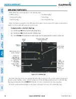
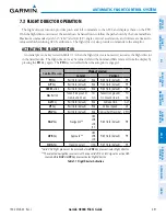
Figure 6-175 Traffic Map Page
Altitude
Mode
Proximity Traffic,
900’ Above,
Level
“No Bearing”
Traffic (Bearing
Undetermined),
Distance 4.0
nm, 500’ Above,
Descending
Traffic Advisory, 500’
Below, Climbing
Traffic
Advisory Off-
Scale, 400’
Below, Level
Traffic Display
Range Rings
Non-Threat
Traffic,
Altitude Not
Reported
Non-Threat Traffic, 2500’
Above, Descending
Altitude
Mode
The Traffic Map Page shows surrounding TAS traffic data in relation to the aircraft’s current position and
altitude, without basemap clutter. Aircraft orientation is always heading up unless there is no valid heading.
Map range is adjustable with the
RANGE
Knob
from 2 to 24 nm, as indicated by the map range rings.
The traffic mode and altitude display mode appear in the upper left corner of the Traffic Map Page.