


190-00726-00 Rev. J
Garmin G900X Pilot’s Guide
383
HAZARD AVOIDANCE
SY
STEM
O
VER
VIEW
FLIGHT
INSTRUMENTS
EIS
AUDIO P
ANEL
& CNS
FLIGHT
MANA
GEMENT
HAZARD
AV
OID
ANCE
AFCS
ADDITIONAL
FEA
TURES
APPENDICES
INDEX
P
ReciPitation
l
imitations
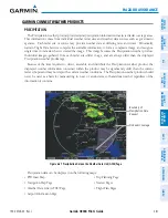
Radar images may have certain limitations:
• Radar composite reflectivity does not provide sufficient information to determine precipitation
characteristics (wet hail vs. rain). For example, it is not possible to distinguish between wet snow, wet
hail, and rain.
• The radar beam may overshoot precipitation occurring below the lowest antenna beam tilt angle (0.5°),
causing no precipitation to be displayed. An individual radar site cannot depict high altitude storms at
close ranges. It has no information about storms directly over the radar site.
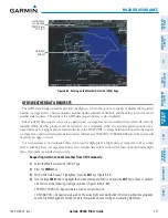
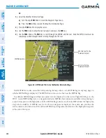
• When zoomed in to a range of 30 nm, each square block on the display represents an area of four square
kilometers.
Figure 6-69 Precipitation Data - Zoomed
Block represents
4 km
2
The following may cause abnormalities in displayed radar images:
• Ground clutter
• Strobes and spurious radar data
• Sun strobes (when the radar antenna points directly at the sun)
• Interference from buildings or mountains, which may cause shadows
• Metallic dust from military aircraft, which can cause alterations in radar scans