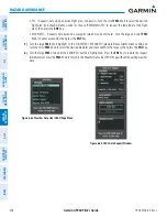


190-00726-00 Rev. J
Garmin G900X Pilot’s Guide
389
HAZARD AVOIDANCE
SY
STEM
O
VER
VIEW
FLIGHT
INSTRUMENTS
EIS
AUDIO P
ANEL
& CNS
FLIGHT
MANA
GEMENT
HAZARD
AV
OID
ANCE
AFCS
ADDITIONAL
FEA
TURES
APPENDICES
INDEX
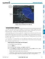
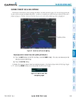
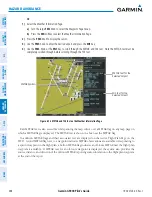
Displaying raw METAR text on the Active Flight Plan Page:
1)
Select the Active Flight Plan Page on the MFD.
2)
Press the
FMS
Knob to activate the cursor.
3)
Turn the large
FMS
Knob to highlight a waypoint with an associated METAR. The METAR text will appear in the
SELECTED WAYPOINT WEATHER window below.
4)
When finished, press the
FMS
Knob to remove the cursor or press the
FPL
Key to exit the Active Flight Plan
Page.
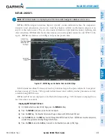
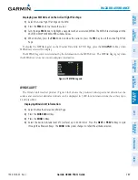
To display the METAR legend on the Weather Data Link (GFDS) Page, press the
LEGEND
Softkey when
METARs are selected for display.
The METAR flag color is determined by the information in the METAR text. The METAR flag is gray when
the METAR text does not contain adequate information.
Figure 6-79 METAR Legend
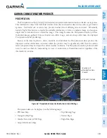
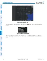
WINDS ALOFT
The Winds Aloft weather product (Figure 6-80) shows the predicted wind speed and direction at the
surface and at selected altitudes. Altitude can be displayed in 3,000-foot increments from the surface up to
42,000 feet MSL.
Displaying Winds Aloft information:
1)
Select the Weather Data Link (GFDS) Page.
2)
Press the
MORE WX
Softkey.
3)
Press the
WIND
Softkey.
4)
Select the desired altitude level: SFC (surface) up to 42,000 feet. Press the
NEXT
or
PREV
Softkey to cycle
through the altitude softkeys. The
WIND
Softkey label changes to reflect the altitude selected.