6. CHART OVERVIEW
6-7
Button name
Description
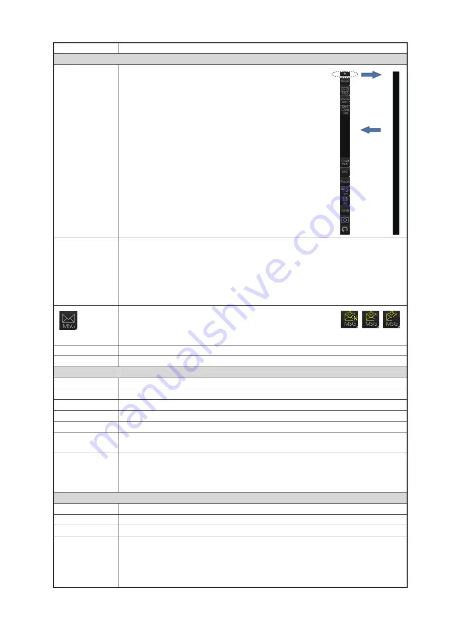
Voyage navigation mode bar
m
Minimize the InstantAccess bar™. To restore the maxi-
mized bar, click anywhere on the bar.
Voyage
[Route]: Selects/deselects routes, and moves route to Voyage planning mode (for
editing).
[User Chart]: Selects/deselects user chart for monitoring.
[Monitor INFO]: Shows the [Monitor Information] dialog box.
[Stop Monitor]: Stops monitoring of route, user chart.
[Instant Track]: Creates a temporary track to return to or make a temporary detour
from the monitored course.
Processes AIS Safety and Navtex messages. If you have un-
read Navtex or Safety messages, the icon changes as shown
right; "N" for unread Navtex, "S" for unread Safety, "S/N" for
unread Safety and Navtex.
Manual Update
Shows the menu for manual update of chart objects.
Mini Conning
Shows or hides the mini conning display.
Chart maintenance mode bar
m
Minimizes the InstantAccess bar™.
AUTO Import
Loads charts automatically.
Manage Charts
Deletes charts; installs (loads) charts manually.
Cell Status
Finds cell status.
License
Enters license information.
Public Key
Shows the current public key. The public key changes each time a new one is
installed.
System
Functions for chart synchronization.
[Sync Config]: Selects the ECDIS units to synchronize.
[Sync Status]: Checks synchronization status.
[Reconvert]: Reconverts outdated SENC charts.
Voyage planning mode bar
m
Minimizes the InstantAccess bar™.
Planning
Creates and edits routes and user charts.
Report
Displays route and user chart reports.
Guide Box
Shows or hides the guide box, which provides range and bearing measurement
between waypoints when creating a route.
Note:
Range and bearing between waypoints can be calculated using either
[Rhumbline] or [Great Circle]. Select the appropriate method from the [Guide Box]
drop-down list in the [Geometry] section of the [NAV TOOLS] menu.
Click
arrow
Click
anywhere
on the bar
S
S/N
Summary of Contents for FCR-2119-BB
Page 66: ...1 OPERATIONAL OVERVIEW 1 40 This page is intentionally left blank ...
Page 134: ...2 RADAR CHART RADAR OPERATION 2 68 This page is intentionally left blank ...
Page 182: ...4 AIS OPERATION 4 22 This page is intentionally left blank ...
Page 198: ...5 RADAR MAP AND TRACK 5 16 This page is intentionally left blank ...
Page 290: ...9 VECTOR S57 CHARTS 9 12 This page is intentionally left blank ...
Page 296: ...10 C MAP CHARTS 10 6 This page is intentionally left blank ...
Page 392: ...16 NAVIGATION SENSORS 16 16 This page is intentionally left blank ...
Page 398: ...17 AIS SAFETY NAVTEX MESSAGES 17 6 This page is intentionally left blank ...
Page 466: ...24 CONNING DISPLAYS 24 4 Example 2 General navigation Example 3 General navigation ...
Page 467: ...24 CONNING DISPLAYS 24 5 Example 4 General navigation Example 5 All waters navigation Silence ...
Page 534: ...FURUNO FCR 21x9 BB FCR 28x9 SERIES SP 6 E3607S01D M This page is intentionally left blank ...
Page 541: ......


