


Ignis Operations Manual (DJI M600 Variant)
Drone Amplified
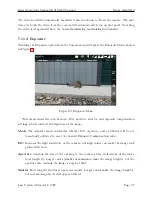
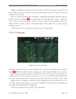
Figure 89: Drag waypoints in the side view to change their altitude.
You can drag the waypoints up and down in order to adjust their altitude, as shown in
Figure 89. In this case, waypoint 2 was above our airspace restriction (light blue region), so
we lowered it to be closer to the ground. When it was moved near the orange-dotted snap
altitude line, its altitude was snapped to the snap altitude (represented by the larger orange
dot appearing under the waypoint).
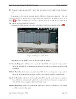
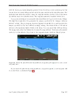
Figure 90: The path through waypoint 2 doesn’t change heading, which allows you to move
waypoint 2 left and right in the side view.
Because the newly-added waypoint 2 was added at the midpoint between waypoints 1
and 3, the path segments into and out of waypoint 2 are aligned in the same direction, as
Last Updated March 12, 2020
Page 108


