


Ignis Operations Manual (DJI M600 Variant)
Drone Amplified
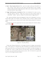
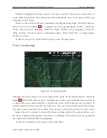
with the brown area representing the ground. If you do not have an elevation map for this
terrain, then the terrain will appear flat and at the same altitude as the takeoff location. The
horizontal axis shows the distance along the waypoint mission, and the vertical axis shows
the altitude above the takeoff location. The waypoint mission is “unrolled” in this view,
You can use your fingers to zoom and scroll around this view to get a better look at things.
The light blue region above the ground is the airspace specified by the “Airspace indicator
altitude” setting. The green zig-zag region is supposed to look like trees, and represents the
airspace specified by the “Low altitude warning” setting. The thin red line at 500 meters
altitude is the maximum flight altitude of the drone. You can adjust this in Drone Setup.
The orange dotted line that follows the terrain is the snap altitude. Newly placed waypoints
will be set to this altitude. To go back to the waypoints menu, touch the “Back” button.
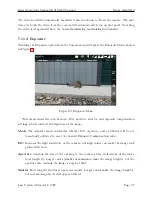
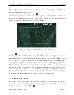
Figure 88: Touch the plus button in the middle of a waypoint path segment to create a new
waypoint there.
If you touch the plus button in the middle of a waypoint segment, a new waypoint will
be created there, as shown in Figure 88.
Last Updated March 12, 2020
Page 107


