


GPS Chart Plotters
Page 97
R
NOTE
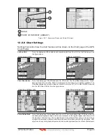
The
draught
window shows the height of the tide water during a 24hr period of time. For example
if the ShuttlePoint knob is pressed up to move the cursor to the top of the Tide Graph this is the High
Water Level and if the cursor is moved to the bottom of the Tide Graph the draught will show the
Low Water Level.
Example 1
You anchor in 15FT of water (under your keel) at a time of day where the water is the highest
(High Water). Let’s say the High Water window shows 5FT and the Low Water window
shows 1FT this means the water under your vessel over a 24 hour period of time could fall
4FT (High Water - Low Water). With your vessel in 15FT of water and with a maximum water
change of 4FT during the day, the worst case situation there will be 11FT of water under your
vessel.
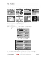
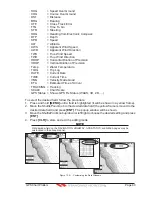
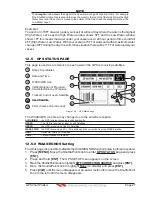
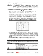
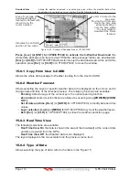
12.5 GPS STATUS PAGE
This page is used as a reference to see how well the GPS is receiving satellites.
W
AAS
3D
H
orizonta
l
Di
l
ution of Precision
4
2
Ship
’
s Coordinates
T
racked, but not used, Sate
ll
ite
U
sed Sate
ll
ite
1
6
3
Vertica
l
Di
l
ution of Precision
WAAS
/
GPS
I
con
Date and
T
ime
5
1
4
6
2
5
3
5
6
U
sed Sate
ll
ite
6
COG (Course O
v
er Ground)
7
D
C
E
A
B
7
14
20
25
31
28
Figure 12.5 - GPS Status page
The WAAS/GPS Icon area may change due to the satellite reception:
ACQUIRING
: the GPS is trying to receive a valid position fix.
GPS2D
: The GPS is receiving at least 2 valid Satellites
GPS3D
: the GPS is receiving at least 3 Satellites.
WAAS 2D/3D
: the GPS is receiving a 2D or 3D position and the correction from the WAAS Satellite.
HDOP
: Horizontal Dilution of Precision
VDOP
: Vertical Dilution of Precision
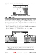
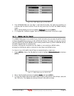
12.5.0 WAAS/EGNOS Setting
From this page it is possible to disable the WAAS/EGNOS function following this procedure:
1. Press
[MENU]
. Move the ShuttlePoint knob to enter
GPS STATUS
page
and press
[ENT]
.
2. Press and hold
[ENT]
. The GPS SETUP menu appears on the screen.
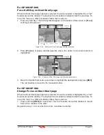
3.
Move the ShuttlePoint knob to highlight
DIFF CORRECTION SOURCE
and press
[ENT]
.
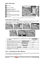
4.
Move the ShuttlePoint knob to highlight
None
(to disable) and press
[ENT]
.
5.
Press
[CLR]
until the menu disappears or an easier method is to move the ShuttlePoint
knob to the left until the menu disappears.
Содержание CP180
Страница 1: ...CP180 CP180i CP300 CP300i Owner s Manual Color GPS Chart Plotters R ...
Страница 4: ...Page 6 GPS Chart Plotters R ...
Страница 12: ...Page 14 GPS Chart Plotters R ...
Страница 38: ...Page 40 GPS Chart Plotters R ...
Страница 48: ...Page 50 GPS Chart Plotters R ...
Страница 60: ...Page 62 GPS Chart Plotters R ...
Страница 68: ...Page 70 GPS Chart Plotters R ...
Страница 76: ...Page 78 GPS Chart Plotters R ...
Страница 80: ...Page 82 GPS Chart Plotters R ...
Страница 108: ...Page 110 GPS Chart Plotters R ...
Страница 118: ...Page 120 GPS Chart Plotters R ...
Страница 120: ...Page 122 GPS Chart Plotters R ...
Страница 126: ...Page 128 GPS Chart Plotters R ...
Страница 130: ...Page 132 GPS Chart Plotters R ...


