


Page 38
GPS Chart Plotters
R
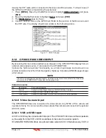
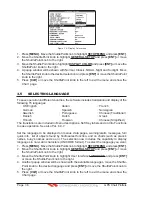
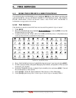
HIGHWAY, NAVIGATION, HIGHWAY, CELESTIAL, GPS STATUS, DSC LOG, DSC
DIRECTORY, NMEA DISPLAY, NMEA DATA, DEPTH TREND, WIND SPEED TREND,
TEMP TREND, SOG TREND, MARKS/WAYPOINTS, USER C-CARD, AIS LIST, FIND and
VIDEO INPUT.
When the Optional FF525 (or FF520) 50/200kHz BLACK BOX FISH FINDER is connected,
any Soft Key can be customized to show FISH FINDER 50kHz, FISH FINDER 200kHz, FISH
FINDER 50/200kHz, FISH FINDER 50kHz/CHART, FISH FINDER 200kHz/CHART screens.
Also when a SI-TEX RADAR Antenna is connected (USA only), any Soft Key can be
customized to show Radar pages, RADAR FULL, RADAR CHART, RADAR OVERLAY and
RADAR/FISH FINDER.
WAAS
3D
AIS LIST
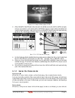
Figure 3.7 - Window options of the selected Soft Key on CP300/CP300i
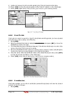
1. To change, momentarily press any of the Soft Keys, then press and hold the Soft Key
you want to customize.
2. A popup window will be shown with the above settings.
3. Move the ShuttlePoint knob up or down to select the desired page.
4. Press
[ENT]
or move the ShuttlePoint knob to the right to save the page to the selected
Soft Key.
3.8
OTHER SETTINGS IN GENERAL SETUP MENU
The
GENERAL SETUP
menu has other selections that allow you to customize:
TIME SETUP
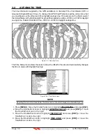
Selects a sub-menu to allow the time setup. It is possible to choose the Time Zone, select
the Daylight Saving among On/Off/Auto and the Time Format, switching 12 or 24 hours
time format.
DATE FORMAT
Allows choosing date format MM-DD-YY or DD-MM-YY.
COURSE UP/NORTH UP
Selections are:
North Up : The Top of the page is fixed to North
Course Up: The top of the page is orientated to the direction the vessel is heading.
KEYPAD BEEP
Allows the beep produced when a key is pressed to be turned on or off.
UNITS OF MEASURE
Units of Measure can be selected for Distance, Speed, Depth, Altitude and Temperature.
NAV AIDS PRESENTATION
Allows the Nav Aids presentation to be drawn using NOAA symbology when US is
selected or International symbols will be used when International is selected. When
selected these functions affect how the icons for Lights, Signals, Buoys and beacons are
displayed.
DISPLAY COLOR
Changes the background colors of the chart page to enhance the visibility of the screen
depending on the surrounding light conditions.
Normal
is recommended when the GPS
Chart Plotter is not exposed to the direct sunlight. When this mode is set the maps are
displayed in order to use colors as similar as possible to ones used in the original paper
Содержание CP180
Страница 1: ...CP180 CP180i CP300 CP300i Owner s Manual Color GPS Chart Plotters R ...
Страница 4: ...Page 6 GPS Chart Plotters R ...
Страница 12: ...Page 14 GPS Chart Plotters R ...
Страница 38: ...Page 40 GPS Chart Plotters R ...
Страница 48: ...Page 50 GPS Chart Plotters R ...
Страница 60: ...Page 62 GPS Chart Plotters R ...
Страница 68: ...Page 70 GPS Chart Plotters R ...
Страница 76: ...Page 78 GPS Chart Plotters R ...
Страница 80: ...Page 82 GPS Chart Plotters R ...
Страница 108: ...Page 110 GPS Chart Plotters R ...
Страница 118: ...Page 120 GPS Chart Plotters R ...
Страница 120: ...Page 122 GPS Chart Plotters R ...
Страница 126: ...Page 128 GPS Chart Plotters R ...
Страница 130: ...Page 132 GPS Chart Plotters R ...


