
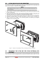
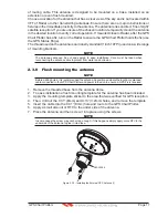


GPS Chart Plotters
Page 25
R
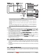
GPS Chart Plotter, and is supplied with mounting hardware kit, interconnection cable and
a RADAR Junction Box.
Please refer to the Radar Installation Manual and Radar Operation Manual available at
www.standardhorizon.com.
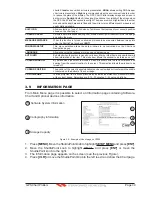
2.10 PERSONAL COMPUTER CONNECTIONS
The GPS Chart Plotter can be connected to output Marks, Routes and Tracks to many PC programs
available. To send or receive User Points the PC Program must be able to receive NMEA WPL and
RTE sentences. Refer to the table below for connection to a Serial DB9 connector.
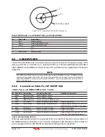
Pin
PC DB9 connection
NMEA connection
2
Receive
Brown
3
Transmit
Blue
5
Signal ground
Green
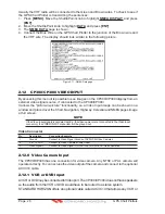
By default Port1 is set to receive or send User Points to and from a PC. The GPS Chart
Plotter may be setup to send and receive the User Points on a different Port using the
following procedure:
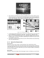
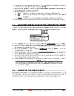
1. Press
[MENU]
. Move the ShuttlePoint knob to highlight
SETUP MENU
and press
[ENT]
.
2. Move the ShuttlePoint knob to highlight
ADVANCED SETUP
and press
[ENT]
or move
the ShuttlePoint knob to the right.
3. Move the ShuttlePoint knob to highlight
IN/OUT CONNECTIONS
and press
[ENT]
or
move the ShuttlePoint knob to the right.
4. Move the ShuttlePoint knob to highlight
SEND/REC RTE & MARKS
and press
[ENT]
or move the ShuttlePoint knob to the right to show the popup window.
5. Move the ShuttlePoint knob to desired Port and press
[ENT]
.
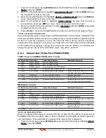
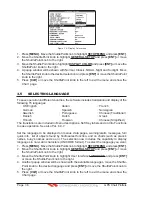
The PC COM settings are:
·
Baud Rate
: 4800
·
Parity
: N
·
Data Bits
: 8
·
Stop Bits
: 1
·
Flow Control : N
The format of the sentences that are sent:
·
MARK
$GPWPL,3249.061,N,00710.651,E,MRK002*22
·
WAYPOINT
$GPWPL,3933.008,N,00639.969,E,WPT012*22
·
ROUTE
$GPWPL,2544.362,N,08011.672,W,WPT003*32
$GPWPL,2543.921,N,08011.481,W,WPT004*31
$GPWPL,2543.493,N,08011.768,W,WPT005*37
$GPRTE,2,1,c,ROUTE01,WPT003,WPT004,WPT005*21
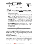
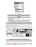
2.11 NMEA DATA PAGE
The NMEA Data Page is very useful to see if a External device (example: Depth Sounder)
is transmitting NMEA sentences to the GPS Chart Plotter. This page can also be used to
see if the GPS Chart Plotter NMEA output is being loaded down by a external NMEA device
the GPS Chart Plotter is connected to. Example:
VHF Radio connected but the radio is not receiving a GPS Position.
Содержание CP180
Страница 1: ...CP180 CP180i CP300 CP300i Owner s Manual Color GPS Chart Plotters R ...
Страница 4: ...Page 6 GPS Chart Plotters R ...
Страница 12: ...Page 14 GPS Chart Plotters R ...
Страница 38: ...Page 40 GPS Chart Plotters R ...
Страница 48: ...Page 50 GPS Chart Plotters R ...
Страница 60: ...Page 62 GPS Chart Plotters R ...
Страница 68: ...Page 70 GPS Chart Plotters R ...
Страница 76: ...Page 78 GPS Chart Plotters R ...
Страница 80: ...Page 82 GPS Chart Plotters R ...
Страница 108: ...Page 110 GPS Chart Plotters R ...
Страница 118: ...Page 120 GPS Chart Plotters R ...
Страница 120: ...Page 122 GPS Chart Plotters R ...
Страница 126: ...Page 128 GPS Chart Plotters R ...
Страница 130: ...Page 132 GPS Chart Plotters R ...


