


ALAN MAP 600
user’s manual
19
4. Press the
button. This will activate a menu which will allow
you to select the search ray from your position (up to 5 Km or
5 miles).
5. Move the Joystick up/down to select the distance, then press
. All references (of the previously selected type) within the
radius defined in the last step will appear.
6. Move the Joystick down to highlight the reference desired,
then press
. The cursor will move to the desired reference in
viewing mode
View Map
.
8.3.4 Map
Info
Map Info is useful to display Information about geographical
Reference Points (Streets, city, etc.) of the map.
1. Move the pointer in the map display on a various reference
point.
2. Press and select
MapInfo
and confirm with
. In the
display the informationpage with the data of the reference
point (e.g. Direction, Distance, …) appears. Down in the display
3 options could be chosen by the cursor and confirmed with
.
a.
, to calculate an Auto-Route to the point,
b.
, to display the object in the map and
c.
, to leave the menu.
8.3.5 Shortcut
on/off
These function creates a line, the shortest way from the actual
position to the chosen Point.
1. Set the pointer away from the actual position to a various
point.
2. Press , choose
Shorcut on
with the cursor and press
finaly
. In the display the shortest way is shown as a line (with
dots).
This f
unction could be deaktivated with the function
Shortcut off
.
8.3.6 Navigating
Route
In the menu
Navigating Route
the settings and functions for
Auto-Routing could be chosen.
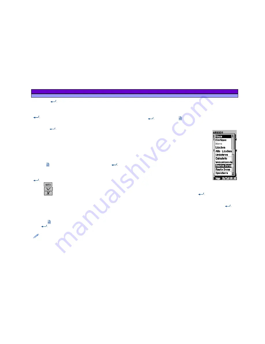
Select with the cursor in the menu Navigating Route and confirm
with
. After pressing you will see the submenu with the
following function, which are shown in the picture:
a.
Append
, to add Start-, Middle- and
Endpoints:
o
from GPS
, actual Position
o
Search Object
o
Nearest Search
, in a special
surrounding
o
Waypoint,
defined Reference
Points.
b.
Insert
to insert Start-, Middle- and
Endpoints:
o
from GPS
, actual Position
o
Search Object
o
Nearest Search
, in a special
surrounding
o
Waypoint,
defined Reference Points.
c.
Move
, to move Points,
d.
Delete
, to delete selected Points (The warning „Are you
sure?“ must be confirmed with
, or denied with
ESC
.)
e.
Delete all
, to delete all Points of a Auto-Route (The
warning „Are you sure?“ must be confirmed with
, or
denied with
ESC
.)
f.
Reverse
, to change Start- and Endpoint and so the
direction of the route
g.
Calculate
, to calculate the Auto-Route
h.
Guide on/off
to activate or deactivate the guiding of the
Auto-Route
i.
Route Detail
, to display the Details of the Route (street,
distance and direction)
j.
Route Demo
, to simulate the way,


