


www.javad.com
127
Localization
Begin by creating a new Project – HOME>COLLECT or
{COLLECT} hard button
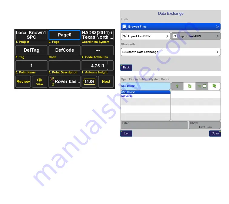
Press the Project at the top left of the screen, Select Create
new Project and give your project a name. Select the
Coordinate System you want for the default coordinate
system of the project. This will determine the initial
Coordinate System of every Page in the project.
In this example, I’ve selected the Texas Coordinate System
of 1983, North Central Zone, with NAVD88 orthometric
heights determined by Geoid12A, and because
J-Field
internally stores all points relative to ITRF2008, I’ve
selected the transformation between WGS84(ITRF2008)
and NAD83(2011). See
Coordinate Systems
section of this
manual for more information (
p. 106
).
It is possible to manually enter points by navigating to the
Collect Review Screen, HOME>COLLECT>REVIEW>ADD,
however for the purposes of this example I am importing
some known coordinates from an ASCII file on a USB thumb
drive.
I’ve selected the file I want to import and
J-Field
directs
me to the Import File Format Screen, where I select which
delimiter(s) separate the fields in my ASCII file and identify
what J-Field should do with each field.
Содержание TRIUMPH-LS
Страница 1: ...U S E R S G U I D E TO T H E T R I U M P H L S E Version 20160121 ...
Страница 17: ...www javad com 17 Introduction ...
Страница 39: ...www javad com 39 Collect Screens ...
Страница 59: ...www javad com 59 Stake Out Points ...
Страница 91: ...www javad com 91 Stake Out Alignments ...
Страница 93: ...www javad com 93 Using ShapeTags and Codes Data Structure ...
Страница 105: ...www javad com 105 Using ShapeTags and Codes ...
Страница 149: ...www javad com 149 Localization ...
Страница 165: ...www javad com 165 Appendix B NGS AntCal Appendix B NGS AntCal Data http www ngs noaa gov ANTCAL Antennas jsp manu Javad ...
Страница 166: ...www javad com 166 Appendix B NGS AntCal Appendix B NGS AntCal Data http www ngs noaa gov ANTCAL ...


