www.javad.com
145
Localization
Note that these points import as “Stake” because there is no
survey data associated with them.
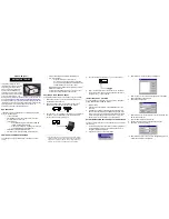
Now we can begin our localization. The left side of the screen
represents the Local, or Design, Coordinate System, while
the right side represents the Geodetic coordinates to which
we will be relating the Local system, in this case by survey.
On the right side, I’ve selected NAD83/NAVD88 as the Survey
Coordinate System. On the left side, I will need to select the
coordinate system I used for the coordinate import. Rather
than leave this Unknown System named “Unknown 2014-
Содержание TRIUMPH-LS
Страница 1: ...U S E R S G U I D E TO T H E T R I U M P H L S E Version 20160121 ...
Страница 17: ...www javad com 17 Introduction ...
Страница 39: ...www javad com 39 Collect Screens ...
Страница 59: ...www javad com 59 Stake Out Points ...
Страница 91: ...www javad com 91 Stake Out Alignments ...
Страница 93: ...www javad com 93 Using ShapeTags and Codes Data Structure ...
Страница 105: ...www javad com 105 Using ShapeTags and Codes ...
Страница 149: ...www javad com 149 Localization ...
Страница 165: ...www javad com 165 Appendix B NGS AntCal Appendix B NGS AntCal Data http www ngs noaa gov ANTCAL Antennas jsp manu Javad ...
Страница 166: ...www javad com 166 Appendix B NGS AntCal Appendix B NGS AntCal Data http www ngs noaa gov ANTCAL ...