R5
SUPREME - Navigation System
OPERATION
7000 118-301, A
Page 97
source, the satellite used for applied corrections is also displayed below the list.
‗No
SBAS Satellite In Use
‘ will be displayed if a correction source another than SBAS is
selected.
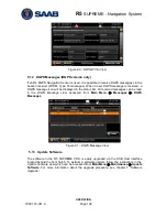
Figure 81
– SBAS Info
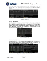
5.11.3
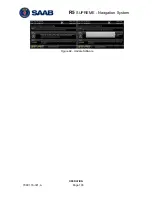
Satellite Info
The
Satellite Info
view shows information relating to GPS satellites that the R4
Navigation Sensor is receiving or expecting to receive signals from. The view displays
the ID, elevation and azimuth of each satellite, and current signal to noise ratio (SNR)
of each satellite‘s signal. The elevation value represents the satellite‘s angular height
above the horizon. The azimuth value represents the satellite‘s angular horizontal
position, counted clockwise from north.
Figure 82
– Satellite Info
5.11.4
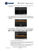
Closest Beacons
This view shows a list of the ten closest beacon stations. To show more information
about a particular Beacon station, select it in the list and press ―Extended Info‖. The
currently used beacon station is marked with green colour in the list.
Figure 83
– Ten Closest Beacon Stations
Summary of Contents for R5 SUPREME AIS
Page 1: ...OPERATION INSTALLATION MANUAL Saab TransponderTech R5 SUPREME Navigation System ...
Page 2: ...This page is intentionally empty ...
Page 60: ...R5 SUPREME Navigation System OPERATION 7000 118 301 A3 Page 60 5 4 System Menus Tree View ...
Page 103: ...R5 SUPREME Navigation System OPERATION 7000 118 301 A Page 103 Figure 92 Update Software ...


