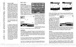


Appendix C: C-MAP Chart Card Features
C-5
A
ppe
ndi
x C:
C-
MA
P Ch
ar
t Ca
rd
Fe
at
ur
es
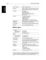
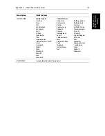
DEPTHS 1
Depth area
DEPTHS 2
Dredged area
DEPTHS 3
Intertidal area
PORTS
Mooring/Warping facility
CAUTION AREAS
Fish haven
OFFSHORE INSTALLA-
TIONS
Diffuser
Obstruction
Production installation
Offshore platform
AREAS, LIMITS
No data area
CARTOGRAPHIC
OBJECTS
Incomplete survey area
NATURAL FEATURES (Ice)
Ice area
Pingo
COMPOSITE OBJECTS
Airport
Anchorage
Channel edge
Deep water route
Defined water
Harbour
Range system
Lighthouse
Mooring trot
Navigation mark, afloat
Navigation mark, fixed in point
Traffic Separation Scheme
System
CARTOGRAPHIC AREAS
Cartographic II25 area
The following chart features are always displayed:
Menu option
Chart features
Summary of Contents for hsb2 PLUS
Page 1: ...hsb2 PLUS Series Fishfinders Owner s Handbook Document number 81195_2 Date August 2002...
Page 2: ......
Page 34: ...1 22 hsb2 Plus Series Fishfinders Database Lists...
Page 64: ...2 30 hsb2 Plus Series Fishfinders Transmitted Data...
Page 110: ...4 14 hsb2 Plus Series Fishfinders MOB...
Page 160: ...5 50 hsb2 Plus Series Fishfinders Review Your Passage Plan...
Page 172: ...6 12 hsb2 Plus Series Fishfinders Data Log Mode...
Page 200: ...8 8 hsb2 Plus Series Fishfinders Worldwide Support...
Page 204: ...A 4 hsb2 Plus Series Fishfinders Appendix A Specifications...
Page 216: ...C 6 hsb2 Plus Series Fishfinders Appendix C C MAP Chart Card Features...
Page 228: ...viii hsb2 Plus Series Fishfinders...