


Chapter 5: Standard Chart Operations
5-5
Di
spla
yin
g Char
t
Obje
ct
an
d S
o
ur
ce
Inf
orma
tio
n
dow and details for the selected object are provided in the lower window.
Use the trackpad to select an object in the upper window and use the soft
keys to scroll up or down the detailed information in the lower window.
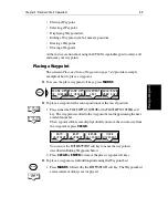
3. Press
CLEAR
to remove the pop-up from the screen and return to the
default display.
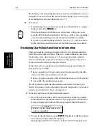
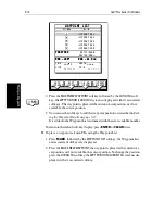
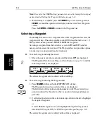
Port Area
At large chart scales port area information is indicated by the symbol
. An
object information pop-up provides the name of the marina or port and a list of
the facilities available.
Where available, details for each facility can be displayed. This information
includes items such as accommodation, slip sizes, fueling, sanitation,
electrical or other maintenance services provided, VHF channels monitored,
and other safety and navigation information.
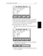
In some areas the chart shows symbols for individual facilities. The facilities
and their associated symbols are illustrated in
Figure 5-2
.
Figure 5-2:
Port Symbols
Summary of Contents for hsb2 PLUS
Page 1: ...hsb2 PLUS Series Fishfinders Owner s Handbook Document number 81195_2 Date August 2002...
Page 2: ......
Page 34: ...1 22 hsb2 Plus Series Fishfinders Database Lists...
Page 64: ...2 30 hsb2 Plus Series Fishfinders Transmitted Data...
Page 110: ...4 14 hsb2 Plus Series Fishfinders MOB...
Page 160: ...5 50 hsb2 Plus Series Fishfinders Review Your Passage Plan...
Page 172: ...6 12 hsb2 Plus Series Fishfinders Data Log Mode...
Page 200: ...8 8 hsb2 Plus Series Fishfinders Worldwide Support...
Page 204: ...A 4 hsb2 Plus Series Fishfinders Appendix A Specifications...
Page 216: ...C 6 hsb2 Plus Series Fishfinders Appendix C C MAP Chart Card Features...
Page 228: ...viii hsb2 Plus Series Fishfinders...