41
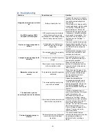
21. Troubleshooting
Problem
Possible cause
Solution
Navigation device does not start
up
Battery capacity too low
Connect the device to a suitable
power source. The device should
then start automatically after a
few minutes.
If the device is not being used for
a prolonged period, please switch
it off entirely. Press the power
button and tap on "Switch off".
No GPS reception / GPS
reception is interrupted
GPS reception may be interfered
with in forests, when you are
surrounded by tall buildings, where
there is heavy cloud cover etc.
Reposition the navigation device
if necessary. At least 4 satellites
are required for navigation. This
information can be called up on
the device under “Settings” ->
“GPS Info”.
Device no longer responds to
entries
Occasionally, overloading may
result in the device no longer
responding
Do a hard reset by holding down
the reset button (inside cover for
USB and Micro SD slots
– above
the Micro SD slot) until device
restarts.
Compass does not align itself
correctly
The compass should be regularly
calibrated
Recalibrate the compass. Hold
the device horizontally for best
compass performance.
The device is not held horizontally
enough.
Do not tilt the device by more
than 70° horizontally when you
are using the compass.
There are sources of interference
in the immediate vicinity
Make sure that there are no
sources of interference such as
magnets or high-voltage power
lines close by.
Barometer values are not
correct
The barometer should be regularly
calibrated
When there are changes in the
weather or you experience great
gains or losses of altitude, you
should calibrate barometer
several times a day.
The destination you are
searching for cannot be entered
The corresponding country map
may not be available.
Please check whether the
corresponding detailed map is
included with the product or is
already preinstalled. Please use
the Activity Manager for any
possible installation that may be
required.
City / street / street number are not
stored in the map material.
Choose a neighbouring city /
street / street number in the input
mask. Alternatively, the
destination point can be set
manually on the “Map” screen.
Despite the very latest up-to-date
versions of maps, there are still
some areas which are not
covered. You can find information
about map coverage on our
Service & Support pages on the
internet. There you can also
report map errors.
The track includes jumps in
altitude
The barometer was not calibrated
prior to the start of the track
recording.
It is recommended that you
calibrate the barometer manually,
by entering an altitude, in
particular before recording a
track.

