10
3.
Main screens
3.1 Navigation screen
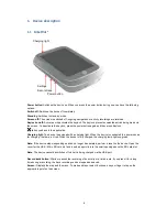
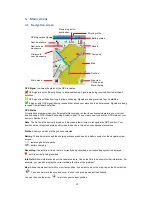
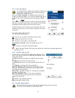
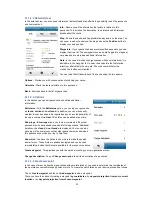
GPS Signal
: Indicates the status of the GPS reception.
GPS signal is not sufficiently strong to allow positioning. Signals are being received from fewer than 3
satellites.
GPS signal is sufficiently strong to allow positioning. Signals are being received from 3 satellites.
A high-quality GPS signal is being received that allows your elevation to be determined. Signals are being
received from at least 4 satellites.
GPS Status
All navigation programs require sufficient satellite coverage in order to continuously determine your current
location using a GPS (Global Positioning System) signal. You can learn how to check the GPS status of your
device in Section 12.4.2.
Note
: The first time the device is turned on it may take a few minutes to recognise the GPS position. Your
position will be recognised more quickly when the device is turned on on subsequent occasions.
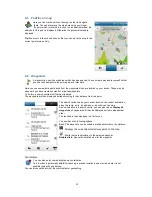
Profile
: Shows you which profile you have selected.
Battery
: The battery status and the charging process are shown by a battery symbol on the navigation view
screen.
- remaining battery capacity
- battery charging
Recording
: If an activity or timed route is currently being recorded, a corresponding symbol is displayed.
- activity currently being recorded
Info Field:
Shows information about the calculated route. Tap on the field to be shown further information. For
example, you can also display the current altitude, the time or the gradient.
Map:
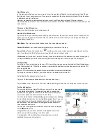
Shows the map extract with your current position. If you want to move the map, tap on the Zoom button
. You can now move the map and zoom in or out using the plus and minus buttons.
You can then use the arrow
to return to your current position.
GPS-signal-quality
Next manoeuvre
Next-but-one
manoeuvre
Distance to
next manoeuvre
Main menü
Map view
Click on map
Move to map
Position
Map
Compass
Speed
Battery status
Bicycle profile
Remaining km to
destination


