™
Page 32 of 67
3 Using the vLoc3 RTK-Pro
3.8 Depth & Current Measurement
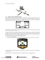
If the depth measurement feature is activated, it is possible to take depth measurement estimations. To take a depth
measurement, first, pinpoint the position of the line as above. Place the tip of the vLoc3 RTK-Pro on the ground making sure it is
vertical and across the line i.e. the compass indicating Forward/Back. Momentarily press the “i” button. The screen will change
to a screen similar to the one below.
Log 2
0.54m
163mA
50°42′59.90570′′N
3°26′35.54358′′W
27.50m
4G
0′1′′ (2DRMS)
Note that if the Omni mode is selected, the orientation of the locator is not important but it is still necessary to pinpoint the line
accurately before taking a depth measurement.
The signal current value will also be displayed. This feature is useful for confirming that the detected signal is radiating from
the correct line. In the event the signal is “bleeding off” onto other services, these signals will generally be less than that of the
originating signal. However, care should be taken as the signal current will gradually reduce over the length of the line, but
watching for a sudden drop in current over distance should indicate that either:
1. There is a ground fault on the line, which is shunting signal to ground.
2. There is a “T” off from the mainline.
3. The operator has migrated from the connected line to a line that has some signal that has bled across from the mainline.
4G
Log
29
50°42′59.90570′′N
3°26′35.54358′′W
63.3mA
27.50m
0′1′′ (2DRMS)
If a valid GNSS/RTK fix is available, an additional screen will be shown with a spirit level. The function of this is described in the
“Datalogging” section.
It is also possible to save the data to the internal memory. This is explained in detail in the “Datalogging” section.


