Topo USA User Guide
58
•
NOAA nautical charts
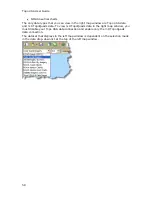
The only data types that you can view in the right map window are Topo USA data
and 3-D TopoQuads data. To view 3-D TopoQuads data in the right map window, you
must disable your Topo USA data connection and enable only the 3-D TopoQuads
data connection.
The dataset that displays in the left map window is dependent on the selection made
in the data drop-down list at the top of the left map window.
Summary of Contents for Topo USA 8.0
Page 1: ...Topo USA 8 0 User Guide ...
Page 2: ......
Page 32: ......
Page 44: ......
Page 76: ......
Page 90: ......
Page 162: ......
Page 204: ......
Page 240: ......
Page 250: ......
Page 274: ......
Page 280: ...Topo USA User Guide 270 Z ZIP Postal Codes 36 Zone 234 Zoom Tools 10 20 Zooming In and Out 10 ...


