A3-AG/N3-AG AGRICULTURE KIT 2.0
User Manual
©
2019 DJI All Rights Reserved.
27
An operation can be paused by toggling the Pause switch. The aircraft will hover and
record the breakpoint, and then the aircraft can be controlled manually. To continue
the operation, tap Resume in the app and the aircraft will return to the breakpoint
automatically and resume the operation. If switching between multiple flight modes is
enabled in DJI Assistant 2 for MG, the Pause Switch will be used as Flight Mode Switch.
Therefore, the aircraft may enter A-mode (Attitude) when toggling the switch. Make sure
to operate the aircraft with caution.
The aircraft will hover at the ending point of the flight route after the operation is
completed. Instead of hovering the aircraft can also be set to perform other flight actions
in the app.
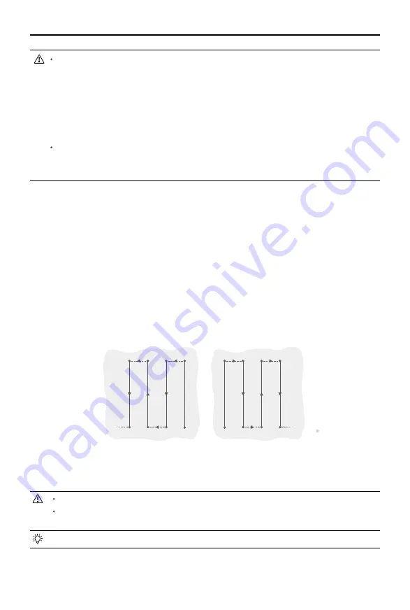
A-B Route Operation Mode
In A-B Route operation mode, the aircraft will travel along a pre-planned route. Operation resumption,
data protection, and the altitude stabilization and obstacle avoidance functions of the radar module
are available in this mode. Use the app to adjust operation efficiency (affecting the flying speed and
spray rate). A-B Route operation mode is recommended for large, rectangular spray areas.
Operation Route
The aircraft travels along a pre-designated square zig-zag route after recording turning points
A and B. Under optimal working conditions, the obstacle avoidance function is available and
the aircraft maintains distance from the vegetation. The length of the dotted lines, called Line
Spacing, can be adjusted in the DJI MG app.
A
B
A
B
R1
R2
L1
L2
R3
R4
L3
L4
R5
……
……
R6
L5
L6
Route L
Route R
Legends
Turning Point
- - - - Line Spacing
Operation Procedure
Maintain line of sight of the aircraft at all times.
Ensure that the GNSS signal is strong. Otherwise, A-B Route operation mode may be
unreliable.
Always inspect operating environments before flying.
Set the operation mode switch button to M (Manual operation mode) when a strong GNSS signal is
present and the onscreen display is Manual Route (GNSS). Then fly the aircraft to a proper height.


