background image

16

Navigation

-or- 
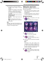
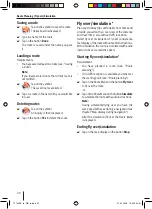
Tap on the button 

Intersection

 and enter the 

road which crosses the entered road.
The map is displayed.
Tap on the button 

Set as Destination

.

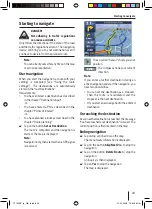
The route is computed and the navigation is 
started.

Note:

You have the possibility after entering the 
destination of starting the navigation or 
e.g. of storing the destination. For this, 
read the chapter "Further functions after 
entering the destination".

The navigation starts as soon as a GPS 
signal is received.

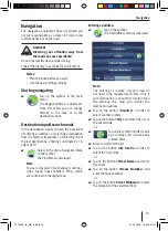
Selecting a destination from the favourites

Requirement: 

You have stored at least one destination 
previously as a favourite (see chapter "Further 
functions after entering the destination").

Tap on the symbol.
The 

Favourites

 menu is displayed.

Tap on the desired symbol.
The address of the destination is displayed.
Tap on the button 

Set as Destination

 to start 

the navigation.

Selecting one of the last destinations

Tap on the symbol.
The 

History 

 menu is displayed.

Tap on the desired symbol.
The address of the destination is displayed.
Tap on the button 

Set as Destination

 to start 

the navigation.

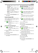
Entering coordinates *

Only available in advanced mode:

Tap on the symbol.
The 

Coordinate Input 

menu is 

displayed.
An example of coordinates in 
degrees of longitude and latitude is 
displayed.

Tap on the button 

Coordinate Display 

Format

 to swap the coordinates between the 

decimal and GMS format (

D

egrees, 

M

inutes 

and 

S

econds).

Tap directly on the latitude in order to select 
it.

With the button 

N/S 

 you can change between 

the northern and southern latitudes.
Tap directly on the longitude in order to select 
it.

With the button 

E/W 

 you can change between 

the east and west longitudes.
Tap on the button 

Done

.

Tap on the button 

Set as Destination

 to start 

the navigation.

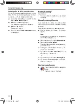
Selecting a destination from the map*

Only available in advanced mode:

Tap on the button 

Plan on Map

.

The map is displayed.
Shift and scale the map, as described in the 
chapter "Working with the map".
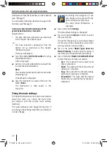
Tap on the location or the street of your 
choice.
The place is marked and its name indicated in 
the lower display bar.
Tap on one of the buttons in order to select 
a location as a destination or a stopover on a 
route.

Add Start

: Using a location for navigation 

and starting navigation


TP100EE_lo_GB_ru.indd   16

TP100EE_lo_GB_ru.indd   16

01.09.2008   13:42:05 Uhr

01.09.2008   13:42:05 Uhr

Содержание TravelPilot 100

Страница 1: ...bile Navigation TravelPilot 100 EE www blaupunkt com Operating and installation instructions long version TP100EE_lo_GB_ru indd 1 TP100EE_lo_GB_ru indd 1 01 09 2008 13 41 58 Uhr 01 09 2008 13 41 58 Uh...

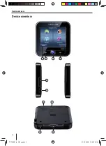
Страница 2: ...2 Device overview Device overview 4 2 3 10 1 5 6 7 9 8 TP100EE_lo_GB_ru indd 2 TP100EE_lo_GB_ru indd 2 01 09 2008 13 41 59 Uhr 01 09 2008 13 41 59 Uhr...

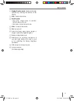
Страница 3: ...creases the volume 5 Memory card slot 6 Socket for power supply mains charger or charger cable for the cigarette lighter 7 Battery compartment cover 8 Photosensor for switching mechanism of day and ni...

Страница 4: ...ity 12 Displaying GPS info 12 Making basic adjustments 13 Setting the time zone 13 Activating the PIN request 14 Setting up the PIN request 14 Blocking unblocking the device 14 Changing the PIN 14 Nav...

Страница 5: ...g a group 29 Changing a group symbol 29 Deleting a group 29 Change POI details 29 Renaming a POI 30 Changing a POI symbol 30 Changing a POI position 30 Entering a new telephone number 30 Entering new...

Страница 6: ...ctivating auto save 37 Set maximum route memory 37 Create NMEA SIRF log 37 Product information 37 Device settings 38 Display 38 Key clicks 38 Language 38 Time 39 Product information 39 Anti theft prot...

Страница 7: ...following tips in order to protect yourself and the device against defects and against injuries or possible mortal danger due to re or explosion Protect the equipment against becoming wet or damp as...

Страница 8: ...ci ed parts are included in the delivery Navigation device Suction cup mounting plate Charging cable for the cigarette lighter Operating instructions Backup DVD Note We recommend the use of original B...

Страница 9: ...tion for fast destination input Access to the most important functions and settings Values are xed for the remaining settings which are optimum for the simple use of the device Advanced Mode or expert...

Страница 10: ...late very simply Foldtheleveratthemountingplateawayfrom the screen Remove the suction cup carefully at the edge of the screen so that air can come between it and the screen Take the suction cup off ca...

Страница 11: ...ie y in order to get to the main menu from any other menu Navigation menu If you have selected the advanced mode the additional functions Route and Manage are available Tap on the symbol in the main m...

Страница 12: ...er to display a list with further suitable entries tap on the Done Longer lists take more time to be displayed Tap on one of the buttons in order to leaf through the list Tap on an entry in order to s...

Страница 13: ...n for you GMT stands for Greenwich Mean Time the mean solar time at the prime meridian without consideration of summer time Tap on the button OK Taponthesymbolinordertochange between the 24 hour and 1...

Страница 14: ...the symbol in the main menu The Settings menu is displayed Tap on the symbol The Anti Theft Protection menu is displayed Tap on the button Protection Setup Tap on the button OK The PIN request is disp...

Страница 15: ...Menu on the symbol The Find Menu is displayed Note You can only select destinations countries cities roads house numbers POIs which are contained in the digital map Entering an address Tap on the symb...

Страница 16: ...navigation Entering coordinates Only available in advanced mode Tap on the symbol The Coordinate Input menu is displayed An example of coordinates in degrees of longitude and latitude is displayed Tap...

Страница 17: ...he local area in the area of the destination or on the route Tap on the menu Where to search on the symbol in order to search for a POI near to your current position or Tap on the menu Where to search...

Страница 18: ...ther position than your current GPS position proceed as follows Enter the route as usual in the destination input Enter an address see chapter Destination input Note You can enter favourites like an a...

Страница 19: ...to select the type of route calculation Fast The route with the fastest travel time is computed Short The route with the shortest travel distance is computed Easy The route with the simplest routing...

Страница 20: ...travel time also without GPS reception Select y over or simulation Fly over consists of a fastdisplayoftheroutewithoutaudioinstructions With simulation the route is simulated with audio instructions...

Страница 21: ...g point for the route or Only available in advanced mode Tap on the button Continue to use the selected address as the last destination of the route The old destination remains as a stopover or Only a...

Страница 22: ...distance with the current route settings method The route settings can be changed at any time If you change the settings travel time and distance can also change Tap during the navigation in the map d...

Страница 23: ...g to navigate DANGER Not adhering to traf c regulations can cause accidents Only follow the directions if the state of the road and the traf c regulations allow it The navigation device will bring you...

Страница 24: ...volume Map display during navigation During navigation different navigation aids and route information are superimposed on the map display DANGER Neglecting the layout of the road can cause accidents...

Страница 25: ...gs seechapter Settings in the navigation menu Further functions during navigation Requirements Starting to navigate or Route simulation demo Cancelling navigation Tap on the action arrow top left duri...

Страница 26: ...in the lower display bar Tap on the button Cursor in order to use further functions after entering the destination Note If you tap on any place in the map during navigation an auxiliary menu with furt...

Страница 27: ...oute options your user data as well as the favourites and last destinations How you work on POIs and symbol as well as changing groups are described in the chapter Managing POIs The chapter Recording...

Страница 28: ...yed The criteria are listed Tap on a search criteria to change the name Tap on the button Clear All to delete the list or Tap on the symbol to delete a POI Managing user data Tap on the Manage menu on...

Страница 29: ...he distance of the POI display If the same setting is to be used for all sub groups Tap on the button Same Visibility in Subgroups to activate the distance ticked or to deactivate it not ticked If you...

Страница 30: ...on the button Select The new position is allocated Entering a new telephone number Tap on the symbol The Phone Number Input is displayed Givethetelephonenumberanameandtapon the button Done Entering n...

Страница 31: ...on the button Done Assigning the track with a new colour The track is indicated in the selected colour on the map Tap on the button with the desired colour or Tap on the button in order to fade out th...

Страница 32: ...e Tap on the button Advanced Mode to change to advanced mode Map display You can change these settings 3D settings Colour pro le 2D terrain Street name display Lane info Select in the menu Settings on...

Страница 33: ...he setting in this menu Lane info Some roads contain lane information so that you can organise yourself correctly at the next crossing This setting speci es whether the display of the lane info is to...

Страница 34: ...turn to the original route If you select another starting point than your currentGPSposition thefunctionisautomatically deactivated Reactivating position xing If you have turned or shifted the map and...

Страница 35: ...the button to leave the menu Program language settings The button displays which program language is used at present TaponthebuttonProgramLanguageinorder to select from a list of available languages...

Страница 36: ...the use is permitted for this function in the country concerned Tap on the button Speed Camera Warning to activate this function ticked or to deactivate it not ticked You can make further settings for...

Страница 37: ...ing When fewer position indications are to be stored less memory is needed for the recording Activating auto save Tap on the button Enable Auto saving to automatically save routes ticked or to deactiv...

Страница 38: ...htness Tap on the button Miniimum brightness Night to set the night time brightness Tap on the button Switch Threshold to set the automatic change over A lower value states that e g already with dusk...

Страница 39: ...ctory settings In the Factory Settings menu you can set navigation software back to the factory settings Note If you set the equipment back to the factory settings your personal settings and stored de...

Страница 40: ...utside of the European Union the guaranteeconditionspublishedbyourresponsible representative are valid The guarantee conditions can be called up or requested by you directly under www blaupunkt com Bl...

Страница 41: ...battery see chapter Charging the battery The battery is empty even though I haven t used the device in a while In the switched off state the device uses a small quantity of energy This can mean that...

Страница 42: ...artmentalisation due to e g multistorey or tall buildings tunnels mountains or sheet metal work The device must have a clear view of the sky Wait until the GPS reception becomes available again The na...

Страница 43: ...43 TP100EE_lo_GB_ru indd 43 TP100EE_lo_GB_ru indd 43 01 09 2008 13 42 10 Uhr 01 09 2008 13 42 10 Uhr...

Страница 44: ...52 77 70 91 410 4078 Sweden S 08 7501850 08 7501810 Switzerland CH 01 8471644 01 8471650 Czech Rep CZ 02 6130 0446 02 6130 0514 Hungary H 76 511 803 76 511 809 Poland PL 0800 118922 022 8771260 Turke...

Отзывы: