


MAP 600 – User’s Manual
Page 42
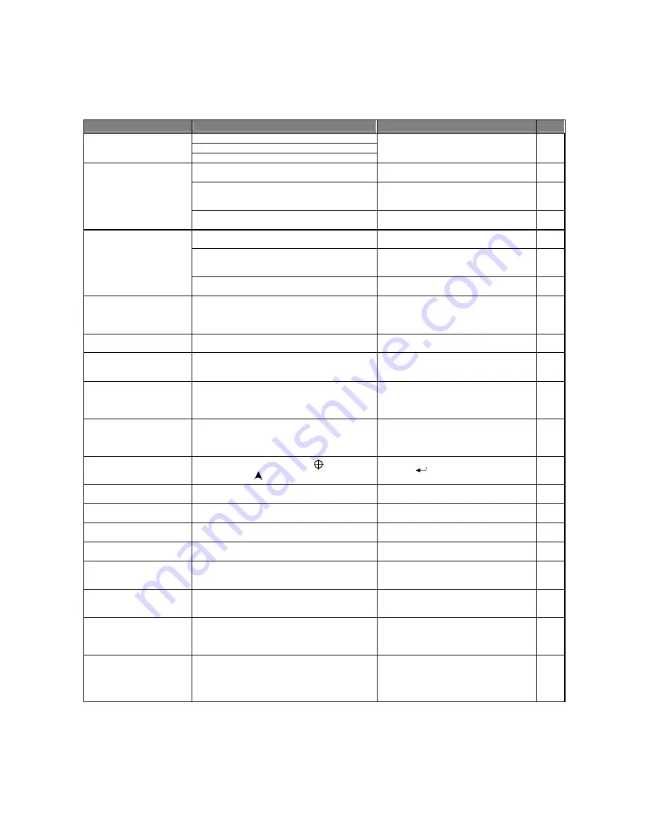
15. Troubleshooting
In case of problems, this table might help to resolve them. If not, contact your supplier or service centre and describe in
detail the problem found.
OQNAKDL
ONRRHAKD B@T RD
RNKT SHNM
QDE-
Batteries are not inserted correctly
Batteries are low
MAP 600 does not turn on
Battery contacts are dirty
Ensure you have inserted the batteries
correctly, that the batteries are charged,
and, if necessary, clean the contacts
4.2.b
This can be expected if the GPS energy saver is
not enabled
Try to insert the energy saver
8.2.b
Rechargeable batteries are not suitable, are
charged incorrectly, and/or are experiencing a
“memory effect”
Ensure the batteries are the correct type,
that they are properly charged, and/or
eliminate the memory effect
4.2.a
Batteries do not last very
long
You are using the display backlighting too
frequently
Backlighting increases consumption.
Reduce its use to a minimum
7.3
There is insufficient open space overhead
Move to a more open area. Try to monitor
the signals using the Satellite page
9.1
MAP 600 is connected too close to interference
devices (televisions, computers, transceivers, air
conditioners, etc)
Move MAP 600 further away from
interference devices
-
GPS does not start the
operating mode
Logical malfunction
Remove the batteries for a few minutes and
try to insert them again
4.2.b
GPS takes a long time to
start the operating mode
You have traveled more than 500Km with the
device turned off and/or with insufficient open
space overhead for reception
Ensure you have enough open space
overhead, then turn off the device and turn
it back on again. You can also try to
initialize it.
5.2
GPS does not update its
position on the display
You are in Simulation mode
Put the device in navigation mode
8.2.b
The displayed time is
incorrect
You have chosen an incorrect time difference (time
zone difference from Greenwich) for your current
position
Select the correct time zone difference
8.7
Measurements displayed
on the GPS are incorrect or
incomprehensible
An incorrect unit of measure for your requirements
has been selected (e.g., nautical units rather than
land units) and/or the reference system on your
map is different from the selected one
Select the correct unit of measurement
depending on your current needs and/or
select the correct reference system
8.3.a
GPS has acquired 3 or
more satellites, but is not
displaying your position
The acquired satellites are all located in one
quadrant of the sky (the
DOP
value (Dilution of
Position) on the
Satellite
page is too high)
When this happens, MAP 600 will not
display your position because the margin of
error is too high. Move to another area to
acquire satellites from other quadrants
-
On the Map page, your
position is no longer
displayed
You have selected the
View Map
mode rather
than
Navigation
mode
Press the
button
Step 4
of 9.2
You are unable to delete
waypoints
The waypoints you are trying to delete have been
inserted in a route
Remove the waypoints you are deleting
from the route
11.6
11.7
You are unable to program
waypoint coordinates
You have selected a map reference with a different
standard from WGS-1984
You can only program waypoint coordinates
using WGS-1984. Select it
8.5
You are unable to navigate
along a route
Programming a route is not enough; you also have
to active it before using the route for navigation
Activate the route for navigation
11.2
The Change Next WP
command is disabled
To navigate using a route and select a next
waypoint, you must first program a route
Program the waypoints and the route
10
11
Map details are not
displayed as they should
be
It is possible to show all details or only those which
you wish to show (using the correct commands)
Please refer to the paragraphs noted to the
right of this box, and follow the instructions
according to your needs
Step 3
of 9.2
The data being read does
not match with the data on
a paper map
It is possible that the reference system or the
design standard of the map are not the same as
are being used in your MAP 600
Please refer to the paragraphs notes to the
right of this box
8.4
8.5
An error message appears
during the recording of the
tracking and every time
you turn on the device
You have reached the maximum capacity of the
tracking
Save or delete the tracking
13.2
A PC or other device is not
able to receive data from
your MAP 600
The market offers many navigation systems which
use different transmission speeds and data output,
as well as various software which is protected by a
special code which restricts the use only to specific
GPS receivers
Enquire as to the compatibility of data
formats
8.2.c
Содержание MAP600
Страница 1: ......


