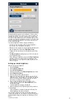


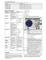


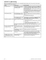

System preferences menu
Menu item
Description
Options
Bearing mode
Determines how all bearing and heading data is displayed
in. This does not affect how the chart or radar displays are
drawn.
• True (default)
• Magnetic
Variation Source
This setting compensates for the naturally occurring offset
of the earth's magnetic field. When set to Auto, the system
automatically compensates, and displays the compensation
value in brackets. To enter your own compensation value,
use the Manual option, then specify the value using the
Manual Variation setting (see below). This value is also
transmitted to any other connected Raymarine instruments.
• Auto (compensation value displayed) (default)
• Manual
Manual Variation
When the Variation Source menu item is set to Manual (see
above), you use the Manual Variation setting to specify the
compensation value that you want to use.
• Range: 0 to 30 degrees, East or West
•
System Datum
In order for your GPS receiver and multifunction display to
correlate accurately with your paper charts, they must be
using the same datum.
The default datum for your multifunction display is WGS1984.
If this is not the datum used by your paper charts, you can
change the datum used by your multifunction display.
When you change the datum for your multifunction display,
the chart grid will subsequently move according to the
new datum, and the latitude / longitude of the cartographic
features will also change accordingly. Your multifunction
display will attempt to set up any GPS receiver to the new
datum, as follows:
• The internal GPS receiver will automatically correlate each
time you change the datum.
• If you have a Raymarine GPS receiver using SeaTalk or
SeaTalk
ng
, it will automatically correlate each time you
change the datum on the multifunction display.
• If you have a Raymarine GPS receiver using NMEA
0183, or a third-party GPS receiver, you must correlate
it separately.
It may be possible to use your multifunction display
to correlate an NMEA 0183 GPS receiver. From the
homescreen go to
Set-up > System settings > GPS Set-up
> View Satellite Status
. If the datum version is displayed, it
may be possible to change it. From the homescreen go to
Set-up > System settings > Data Sources > GPS Datum
.
Note:
Raymarine recommends that you check the
displayed vessel position in the chart application against
your actual proximity to a known charted object. A typical
GPS has an accuracy of between 5 and 15 m.
Customizing your display
287
Summary of Contents for a67
Page 2: ......
Page 4: ......
Page 8: ...8 New a Series New c Series New e Series...
Page 12: ...12 New a Series New c Series New e Series...
Page 20: ...20 New a Series New c Series New e Series...
Page 36: ...36 New a Series New c Series New e Series...
Page 70: ...70 New a Series New c Series New e Series...
Page 100: ...100 New a Series New c Series New e Series...
Page 110: ...110 New a Series New c Series New e Series...
Page 116: ...116 New a Series New c Series New e Series...
Page 158: ...158 New a Series New c Series New e Series...
Page 182: ...182 New a Series New c Series New e Series...
Page 204: ...204 New a Series New c Series New e Series...
Page 214: ...214 New a Series New c Series New e Series...
Page 236: ...236 New a Series New c Series New e Series...
Page 240: ...240 New a Series New c Series New e Series...
Page 260: ...260 New a Series New c Series New e Series...
Page 290: ...290 New a Series New c Series New e Series...
Page 306: ...306 New a Series New c Series New e Series...
Page 314: ...314 New a Series New c Series New e Series...
Page 329: ......
Page 330: ...www raymarine com...