


Menu item
Description
Options
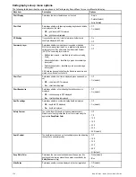
Nav. Marks
Determines whether navigation marks are displayed on the chart:
•
Off
— navigation marks are NOT displayed.
•
On
— navigation marks are displayed.
• Off
• On (default)
Nav. Marks Symbols
Determines which set of navigation mark symbols is used —
International, or US. These symbols correspond to paper charts.
• International (default)
• US
Light Sectors
Determines whether the sector of light cast by a fixed beacon is
displayed or not.
•
Off
— sector of light is NOT displayed.
•
On
— sector of light is displayed.
• Off
• On (default)
Routing Systems
Determines whether routing data is displayed or not.
•
Off
— routing data is NOT displayed.
•
On
— routing data is displayed.
• Off
• On (default)
Caution Areas
Determines whether caution data is displayed or not.
•
Off
— caution data is NOT displayed.
•
On
— caution data is displayed.
• OFF
• ON (default)
Marine Features
When this menu item is set to On, the following water-based
cartographic features are displayed:
• Cables.
• Nature of seabed points.
• Tide stations.
• Current stations.
• Port information.
• Off
• On (default)
Land Features
When this menu item is set to On, land-based cartographic
features are displayed.
• Off
• On (default)
Business Services
When this menu item is set to On, symbols indicating the location
of a business will be shown.
• Off
• On (default)
Panoramic Photos
Determines whether panoramic photos are available for landmarks
such as ports and marinas.
• Off
• On (default)
Roads
Determines whether major coastal roads are displayed on the
chart:
•
Off
— coastal roads are NOT displayed.
•
On
— coastal roads are displayed.
• Off
• On (default)
Additional Wrecks
Determines whether extended information for new wrecks is
displayed.
• Off
• On (default)
Aerial Overlay
Determines the areas of the chart covered by the aerial photo
overlay feature.
• On Land (default)
• On Land and Shallow
• On Land and Sea
Colored Seabed Areas
Provides greater definition of the seabed. This applies only to
limited areas where the extra detail is available.
• Off (default)
• On
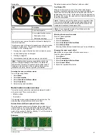
Selecting the cartography set-up menu
From the chart application:
1. Select
Menu
.
2. Select
Set-up
.
3. Select
Cartography
.
The cartography menu options are displayed.
Chart application
157
Summary of Contents for a67
Page 2: ......
Page 4: ......
Page 8: ...8 New a Series New c Series New e Series...
Page 12: ...12 New a Series New c Series New e Series...
Page 20: ...20 New a Series New c Series New e Series...
Page 36: ...36 New a Series New c Series New e Series...
Page 70: ...70 New a Series New c Series New e Series...
Page 100: ...100 New a Series New c Series New e Series...
Page 110: ...110 New a Series New c Series New e Series...
Page 116: ...116 New a Series New c Series New e Series...
Page 158: ...158 New a Series New c Series New e Series...
Page 182: ...182 New a Series New c Series New e Series...
Page 204: ...204 New a Series New c Series New e Series...
Page 214: ...214 New a Series New c Series New e Series...
Page 236: ...236 New a Series New c Series New e Series...
Page 240: ...240 New a Series New c Series New e Series...
Page 260: ...260 New a Series New c Series New e Series...
Page 290: ...290 New a Series New c Series New e Series...
Page 306: ...306 New a Series New c Series New e Series...
Page 314: ...314 New a Series New c Series New e Series...
Page 329: ......
Page 330: ...www raymarine com...