

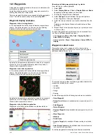


15.1 Chart application overview
The chart application provides an electronic chart with passage
planning and navigation features. It combines 2D and 3D
viewpoints and provides a variety of cartographic information
regarding your surroundings and charted objects.
Typical uses for the chart application include :
• Monitor your vessel location and heading.
• Interpret your surroundings.
• Measure distance and bearing.
• Navigate using waypoints.
• Plan, and Navigate using routes.
• Monitor fixed and moving objects using radar overlay.
• Monitor vessels in your vicinity using AIS data.
• Keep track and record your course.
• View information for charted objects.
• Overlay NOWRad weather information.
• Overlay aerial photos and other chart enhancements
Note:
To obtain full 3D detail, you must have chart cards
containing 3D cartography for the appropriate geographic
area.
You can also use your multifunction display to customize your
chart application to your own particular requirements and
circumstances. You can:
• Alter the way the chart is drawn in relation to your vessel
and the direction you are travelling in (chart orientation and
motion mode).
• Manage and edit chart data you have entered.
• Control the level of detail displayed on-screen.
Chart datum
The chart datum setting affects the accuracy of the vessel
position information displayed in the chart application.
In order for your GPS receiver and multifunction display to
correlate accurately with your paper charts, they must be using
the same datum.
The default datum for your multifunction display is WGS1984.
If this is not the datum used by your paper charts, you can
change the datum used by your multifunction display, using the
system preferences page. The system preferences page can be
accessed from the homescreen:
Set-up > System Settings >
System Preferences > System Datum
.
When you change the datum for your multifunction display, the
chart grid will subsequently move according to the new datum,
and the latitude/longitude of the cartographic features will also
change accordingly. Your multifunction display will attempt to set
up any GPS receiver to the new datum, as follows:
• If your multifunction display has a built in GPS receiver it will
automatically correlate each time you change the datum.
• If you have a Raymarine GPS receiver using SeaTalk or
SeaTalk
ng
, it will automatically correlate each time you change
the datum on the multifunction display.
• If you have a Raymarine GPS receiver using NMEA0183, or a
third-party GPS receiver, you must correlate it separately.
It may be possible to use your multifunction display to correlate
an NMEA0183 GPS receiver. From the homescreen go to
Set-up > System settings > GPS Set-up > View Satellite
Status
. If the datum version is displayed, it may be possible
to change it. From the homescreen go to
Set-up > System
settings > Data Sources > GPS Datum
.
Note:
Raymarine recommends that you check the displayed
vessel position in the chart application against your actual
proximity to a known charted object. A typical GPS has an
accuracy of between 5 and 15 m.
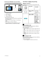
Chart cards overview
Chart cards provide additional cartographic information.
Obtain detailed cartographic information for the area that
you navigate using Navionics® chart cards. To check the
current availability of Navionics chart card types, please
visit
www.navionics.com
or
www.navionics.it
. The amount of
cartographic detail shown varies for different areas and for
different scales. The chart scale in use is indicated by the
on-screen chart scale, the number represents the distance the
line represents in nautical miles across the chart.
You can remove and insert chart cards while a chart is displayed
provided that you follow the correct procedure. The chart
information is retained on-screen until the chart application
redraws the screen; for example, when you pan outside the
current area, or use the
Range control
to change the chart
scale.
Caution: Care of chart and memory
cards
To avoid irreparable damage to and / or loss of data
from chart and memory cards:
• Ensure that chart and memory cards are fitted
the correct way around. DO NOT try to force a
card into position.
• DO NOT save data (waypoints, routes, and
so on) to a chart card, as the charts may be
overwritten.
• DO NOT use a metallic instrument such as a
screwdriver or pliers to insert or remove a chart
or memory card.
Chart compatibility
Your multifunction display is supplied with a base map and
depending on unit a Navionics chart card. You may also
purchase Navionics chart cards to get enhanced chart details
and additional chart features.
Your multifunction display is compatible with the following
Navionics chart cards:
• Ready to Navigate
• Silver
• Gold
• Gold+
• Platinum
• P
• Fish'N Chip
• Hotmaps
Note:
Refer to the Raymarine website (
www.raymarine.com
)
for the latest list of supported chart cards.
140
New a Series / New c Series / New e Series
Summary of Contents for a67
Page 2: ......
Page 4: ......
Page 8: ...8 New a Series New c Series New e Series...
Page 12: ...12 New a Series New c Series New e Series...
Page 20: ...20 New a Series New c Series New e Series...
Page 36: ...36 New a Series New c Series New e Series...
Page 70: ...70 New a Series New c Series New e Series...
Page 100: ...100 New a Series New c Series New e Series...
Page 110: ...110 New a Series New c Series New e Series...
Page 116: ...116 New a Series New c Series New e Series...
Page 158: ...158 New a Series New c Series New e Series...
Page 182: ...182 New a Series New c Series New e Series...
Page 204: ...204 New a Series New c Series New e Series...
Page 214: ...214 New a Series New c Series New e Series...
Page 236: ...236 New a Series New c Series New e Series...
Page 240: ...240 New a Series New c Series New e Series...
Page 260: ...260 New a Series New c Series New e Series...
Page 290: ...290 New a Series New c Series New e Series...
Page 306: ...306 New a Series New c Series New e Series...
Page 314: ...314 New a Series New c Series New e Series...
Page 329: ......
Page 330: ...www raymarine com...