Appendix B Menu List and Materials
B-16
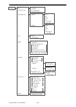
View
Chart View
C
−
MAP MAX
Multi View Mode
[Chart Type]
C
−
MAP MAX
newpec
Display Fishing Area
[Multi View Mode]
Single View
Top
−
Bottom
Right
−
Left
Select Area from View1 for View2
(Page 1/4)
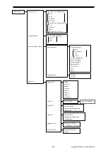
[Depth Shading]
Mode
[Highlight Depth Area]
Minimum Depth
Maximum Depth
Safety Contour
Next
(Page 2/4)
[Land Setting]
Point of Interested
Land Elevation
Roads
Land Elevation Value
Land Marks
River & Lake
Back
Next
(Page 3/4)
[Marine Settings]
Name Tags
Tides and Currents
Place Name
Seabed Type
Port & Service
Attention Areas
Track & Routes
Under Water
[Light]
Naviagtion Aids & Light Sector
Light Sector Level
Back
Next
(Page 4/4)
[Chart Setting]
VAD (Value Added Data)
Chart Boundaries
[Combo box]Select Boundaries
[Under Water Setting]
Wrecs Depth Label
Diffusers Depth Label
Obstructions Depth Label
Rocks Depth Label
Graticule
Back
Summary of Contents for JMR-5400 Series
Page 2: ......
Page 58: ...Section 2 Basic Operations and Mode Screen 2 32 ...
Page 86: ...Section 4 Route Planning 4 18 ...
Page 96: ...Section 5 Route monitoring 5 10 ...
Page 124: ...Section 7 Specifications 7 2 ...
Page 205: ......


