background image


MapSight   User   Manual   

Page   41   

www.gemapsight.com/support   

MS-101-14-12-34.0 


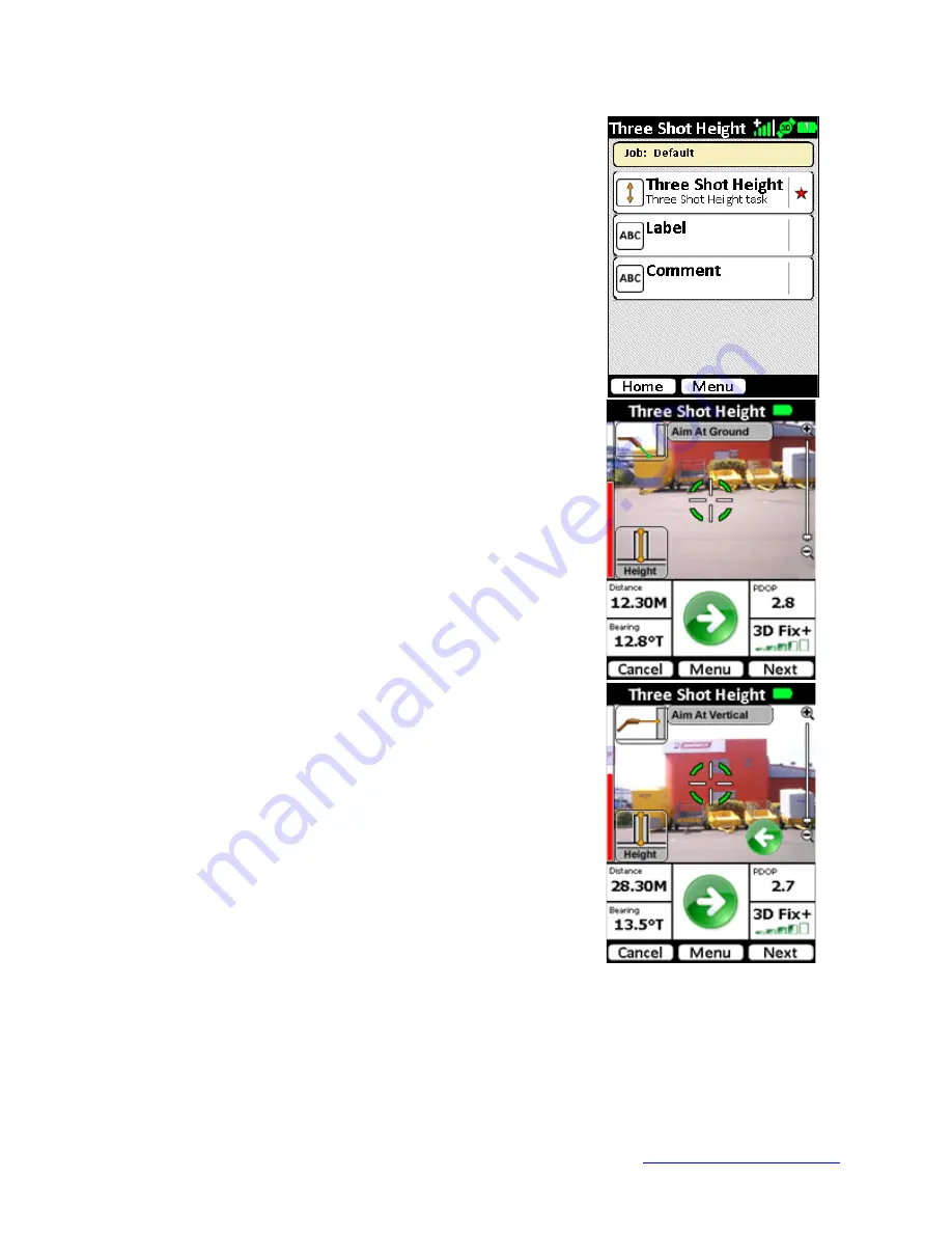
The default tasks for the Three Shot Height MapSight Tool will 
be shown.  A red star will indicate the mandatory tasks. 
Tap the 

Three Shot Height

 task to start the video preview 

screen 


Aim at the ground in front of the object. 
Aim at a level, flat area in front of the object to be measured 
and tap the Next button to proceed. 


Aim at the vertical face of the object. 
Tap the Next button to proceed or tap the Previous button to 
return to the previous step. 


Summary of Contents for MapSight

Page 1: ...ght Thank you for purchasing this GE product In keeping with the GE ecomagination initiative please consider the option to recycle the packaging material and donate or recycle any product you are no longer using To read more about GE s ecomagination commitment visit www ge com ecomagination ...

Page 2: ...tive owners Copyright ikeGPS All rights reserved Customer Assistance For customer assistance visit our webpage www gemapsight com support About this User Manual This User Manual provides a combined reference for the use of MapSight OS and its associated features on MapSight products and Windows Mobile 6 operating system that is pre installed on these devices Note This document has been optimized f...

Page 3: ...ertures Avoid staring into the laser beam This product complies with 21CFR1040 10 and IEC60825 1 200 WARNING The MapSight unit contains a magnetic compass Using the unit near magnetic e g objects containing ferrous substances or electromagnetic fields e g electrical wires may cause the compass bearing to be inaccurate Laser radiation emits from this aperture Magnetic compass located here ...

Page 4: ... 620 02780 GE MapSight User Manual MS 101 14 12 34 0 THIS PAGE INTENTIONALLY BLANK ...

Page 5: ...ng the MapSight application 25 MapSight Home screen 26 Viewing and changing the Settings 26 GPS Settings 27 Antenna Settings 29 Camera Settings 30 Laser Settings 31 Data Settings 32 Changing the Default Job name 33 Exiting the MapSight application 34 MapSight Tools 35 Introduction 35 Target Position 36 3 Shot Height 40 Missing Line 43 Span Height 46 Photo Only 50 Local Point 52 Tree Assessment 55 ...

Page 6: ... Software 85 Microsoft Software License Terms for Windows Mobile 6 Software 92 Battery Safety 96 Battery warnings 96 Transportation 96 Disposing of your MapSight and battery packs 96 Hardware Warranty Software Maintenance and Support 97 Certifications and Classifications 97 Laser Classification 97 Export Control Classification Number ECCN Certification 97 Harmonized Tariff Schedule HTS Classificat...

Page 7: ...ight 115 Adjusting the backlight timer 115 Power Settings 116 Exploring files 117 Closing running programs 118 Switching between running programs 118 Viewing memory allocation for programs 118 Changing settings 119 Using on device help 119 Backing up data 120 Copying data from a peripheral device 122 Communicating with a Desktop Computer 123 Getting to Know Programs and Settings 124 Understanding ...

Page 8: ... MapSight User Manual Page 4 www gemapsight com support MS 101 14 12 34 0 THIS PAGE INTENTIONALLY BLANK ...

Page 9: ...aser rangefinder mobile computer and precision GPS This hardware combination makes the MapSight a powerful measuring device The MapSight is capable of in field measurements assisted with augmented reality instructions and back office measurements performed straight from and MapSight photos For additional information in regards to unit warranty registration tutorial videos and software downloads vi...

Page 10: ... cover USB Cable Cable to allow transfer of data between MapSight unit and Windows based PC Stylus and Handstrap Stylus to allow accurate selection tapping of on screen buttons Handstrap to allow safe grip of the MapSight unit Screen Protector Recommended additional protection for the LCD screen Packed in Documentation Pack Field Accessories Also supplied are a number of additional Field Accessori...

Page 11: ...e MapSight View software allows you to build custom forms that allow capture of data that that suits your day to day field collection needs MapSight View also allows you to measure the height and width of objects such as utility poles MapSight View allows MapSight Tools to be used together in custom workflows to capture readings for the objects you are targeting Combined with the ability to add cu...

Page 12: ... MapSight User Manual Page 8 www gemapsight com support MS 101 14 12 34 0 An example configuration of a MapSight kit is depicted below Tripod ...

Page 13: ...utton 8 Task Manager button 9 Microphone 10 Today screen button 11 Speaker 12 Four way directional button 13 Power button 14 Context menu button 15 Notification indicator green LED 16 Enter button 17 Touchscreen LCD display 18 Laser Reference Plane distance measured from this surface 19 Battery door latch 20 Hand strap 21 Battery door 22 Body molding 23 Connector Protector Buttons 7 8 10 14 may be...

Page 14: ...ible laser radiation from the front apertures Avoid staring into the laser beam 26 USB Client mini B 27 12V DC jack 28 9 pin serial port 29 USB Host mini A 32 3D Compass As MapSight contains a magnetic compass using the unit near magnetic or electromagnetic fields may cause the compass bearing to be inaccurate 32 External Antenna Port 32 24 25 26 27 29 28 Rear Communications module Front Data capt...

Page 15: ...nal licensing may be required for MapSight Tools that are not provided as part of the standard MapSight configuration More information about MapSight options and the solution specific MapSight Tools is available from your MapSight reseller Turning your MapSight on for the first time To use your MapSight unit you need to insert the battery and charge the unit for first use Remove the MapSight unit ...

Page 16: ... cover Refit the handstrap and connector protector Fit the plug that is applicable to your operating region to the AC charger Your AC charger comes with interchangeable plugs for USA UK Europe and Australasia Connect the AC charger to the wall socket Turn the wall socket on Connect the charger power tip to the MapSight power socket ...

Page 17: ... screen Home screen and control buttons Whenever you reset your MapSight unit or return to the Home screen Home screen To top bar of the Home screen provides access to the Start menu and contains icons notifying the status of system settings Tapping the Start button accesses the start menu and underlying options The center part of the Home screen contains the touch buttons to access MapSight appli...

Page 18: ...ocal operating area Installing and charging the battery New batteries should always be fully charged in your MapSight units to ensure that they are conditioned for optimal capacity Charging batteries in the MapSight unit ensure that their internal capacity gauge is correctly calibrated to reflect the correct capacity of the battery With the battery securely in place and external power applied tap ...

Page 19: ...LED stop blinking this indicates that the charge level is around 98 The mAH consumed value may slowly decrease as the battery capacity is calibrated for optimal use Once the charge indicator red LED stops blinking and the mAH consumed value stops decreasing then the battery has been fully charged For fully charged new batteries the mAH consumed value will be near zero For older batteries the mAH c...

Page 20: ...This should cause the LCD screen to dim WARNING Changing batteries should only be performed when the unit is suspended or disconnected from external power Similar to the Turning your MapSight on for the first time instructions replace the battery by releasing the lock remove the battery cover remove the existing battery fit the new uncharged battery replace and relock the battery cover Un suspend ...

Page 21: ...have a charged battery pack It is strongly recommended that all new batteries are initially fully charged in the MapSight unit ensure that their internal capacity gauge is correctly calibrated to reflect the correct capacity of the battery After this initial full charge they can then be charged in the Travel Charger Device Features CAUTION Only use authorized devices with the Travel Charger Failur...

Page 22: ...he battery pack may cause it to overheat rupture or ignite and cause serious injury Be sure to follow these safety rules Do not heat the battery pack or place it in fire or direct sunshine Do not install the battery pack backwards Do not connect the battery terminals with any metal object such as wire Do not solder onto the battery pack Do not disassemble or modify the battery pack In the rare eve...

Page 23: ...ravelled a long distance e g plane flights or shipping to a new location To ensure the highest possible compass accuracy it is recommended that the MapSight be calibrated at least once per month Where you should calibrate The Compass Calibration application should be used in a clean magnetic free environment This means Keep away from large metal objects e g cars steel poles desk frames filing cabi...

Page 24: ... Calibrate Compass icon on the main screen Review the Compass Calibration welcome screen and tap the screen to continue Step 1 North Orientation At the align screen move your MapSight until the red line is best aligned with the N Note The bar indicator at the bottom of the screen will move into the green zone when correctly aligned ...

Page 25: ...count gets to 5 o For each rotation the key is to keep the MapSight aligned with the reference direction as shown When you are ready tap the screen to start You will be given a countdown Ready Set Go and a 10 second count will begin for each required rotation Rotate your MapSight smoothly in the manner shown during the 10 second count maintaining alignment with the direction reference noted earlie...

Page 26: ... MapSight User Manual Page 22 www gemapsight com support MS 101 14 12 34 0 Step 2 Rotation Orientation 1 Step 3 Rotation Orientation 2 Step 4 Rotation Orientation 3 ...

Page 27: ...ns new compass calibration parameters will be calculated and stored Note During the calculation phase the display will show the final countdown time and this on screen cursor will change to the working cursor A summary will be presented indicating that the process is complete Tap Quit to close the Compass Calibration application ...

Page 28: ... MapSight User Manual Page 24 www gemapsight com support MS 101 14 12 34 0 MapSight Application MapSight Tools Data Transfer to Desktop MapSight Data Capture Application ...

Page 29: ...ht installed but MapSight Tools are accessible dependent on product license purchased Starting the MapSight application To start the MapSight application either tap the MapSight icon on the main Home screen or from the Start menu Launch MapSight from Home screen Launch MapSight from Start menu The MapSight application will start and progress through the startup screen on to the Home screen with a ...

Page 30: ... below the status icons 3 MapSight Tools and Custom Forms The scrollable list of MapSight Tools and or custom forms will show in the main part of the screen 4 Action Buttons At the bottom of the screen action buttons will show Buttons will differ depending on the options relevant to the on screen display Viewing and changing the Settings On the Home screen tap the Menu button to display the availa...

Page 31: ...wer or increase the Maximum PDOP The default Maximum PDOP value is 6 A lower value may result in more accurate the fix but this may increase the time to get a fix A higher Maximum PDOP may reduce the time to get a fix but will likely decrease the accuracy of the fix Enforce Maximum PDOP checkbox When Enforce Maximum PDOP is enabled data capture will not be possible if the GPS readings exceed the M...

Page 32: ...BAS system from the following options Disabled North America WAAS Europe EGNOS Japan MSAS India GAGAN WARNING Selecting the wrong SBAS system will make the GPS less accurate Anyone outside the regions specified should set the SBAS option to Disabled Hardware Revision One MapSight units This setting is not required Hardware Revision One MapSight units as it is handled automatically ...

Page 33: ...he distance to behind the MapSight unit that a connected external antenna is located Tapping the Save button stores the Vertical and Horizontal values to memory and adjusts GPS location and Laser range calculations accordingly WARNING When an external antenna is not connected to the MapSight unit the GPS Antenna Offset Vertical and Horizontal values should always be saved as 0 00 This example show...

Page 34: ... on the slider The display time out ranges between 0 and 5 seconds EXIF Local Pos Fields Populated As options The Exchangeable Image File Format EXIF fields are pieces of information stored with each photo These use the EXIF v2 2 standard format for digital photos such as the time and date but also include fields for target positional data which MapSight records With each reading MapSight records ...

Page 35: ...distance only when the Capture button is press Where One Shot Laser Mode has been selected the capture preview Distance value will be shown as Single WARNING Regardless of which the Laser Mode is selected the laser rangefinder emits a pulse that may cause infrared transmission detectors e g speed camera detectors to be activated The Measurement Units option controls the selection between recording...

Page 36: ...g Use the folder tree view to browse and select the required folder Tap Save or ok to update the data folder or tap Cancel to not change the Current Data Folder WARNING The Data Folder path must be a valid existing folder on your MapSight unit to correctly record captured data Note While it is possible to store captured data in MapSight internal memory it is recommended that data be stored on an i...

Page 37: ...ame to select and access the Set Job menu The virtual keyboard will appear to allow data entry of a new job name Using the keyboard to enter an alpha numeric description of the job Alternatively a list of existing jobs can be shown by tapping the drop down arrow to the right of current job name field Tapping an existing job name will update the job name to the selected job Once the correct job nam...

Page 38: ...creen and the Job name will be updated as selected Exiting the MapSight application On the Home screen tap the Menu button to display the available options Tap the exit icon to close the MapSight application At the Exit MapSight confirmation either tap OK to exit the application or Cancel to return to the Home screen ...

Page 39: ...ill show Buttons may differ depending on the options relevant to the on screen display Distance The laser rangefinder distance from the MapSight unit to the targetted object Bearing The Compass bearing from the the MapSight unit towards the targetted object This initially displays a M Magentic bearing but as the GPS obtains a fix this will update to T True to adjust for localised magnetic declinat...

Page 40: ...t at a remote object such as a tree pole or building and capture its GPS location using the on board GPS laser range finder and compass One shot and you re on to the next object Target Position mode is the standard mode for capturing a single geo referenced target and associated photo Step by step Select the Target Position MapSight Tool from the Home menu ...

Page 41: ...mits of the instrument An orange border indicates that the reading can be used but there may have been manual adjustments made to allow capture outside the default recommended settings Hold the MapSight unit steady ensure you re still on target and tap the Next button or capture soft key Exposure Control If lighting conditions are an issue use the Exposure increase decrease buttons Right or Left a...

Page 42: ...eturn to the preview screen The information screen will provide instrument readings in regards to the local MapSight position target position and other instrument readings Tap the Next button to save the target and continue Where there is a successful recording a green tick will appear alongside the task From here the information can be abandoned tap the Home button retaken tap Target Position aga...

Page 43: ...K button to store the Label text On the Comment screen use the virtual keyboard to enter a more detailed description of the target Tap the Cancel button to exit the Comment entry Tap the OK button to store the Comment text Once all information is correct tap Save to save the target information Or tap Home to abandon the target and delete the recorded data The Target Position MapSight Tool will ret...

Page 44: ...ded through a series of steps to measure the vertical height of an object where the base of the object is not necessarily visible When performing 3 Shot Height measurements the use of a MapSight low magnetic signature tripod is strongly recommended as this will assist in minimizing potential error introduced due to changing the hand held height of the MapSight during the measurement Step by step S...

Page 45: ...l indicate the mandatory tasks Tap the Three Shot Height task to start the video preview screen Aim at the ground in front of the object Aim at a level flat area in front of the object to be measured and tap the Next button to proceed Aim at the vertical face of the object Tap the Next button to proceed or tap the Previous button to return to the previous step ...

Page 46: ... is a successful recording a green tick will appear alongside the task From here the information can be abandoned tap the Home button retaken tap Three Shot Height again to delete the photo and re enter the video preview and data entered into non mandatory Label and Comment fields Tap the Label task button to enter the Label entry screen Tap the Comment task button to enter the Comment entry scree...

Page 47: ...l distance between any two objects When performing Missing Line measurements the use of a MapSight low magnetic signature tripod is strongly recommended as this will assist in minimizing potential error introduced due to changing the hand held height of the MapSight during the measurement Step by step Select the Missing MapSight Tool from the Home menu ...

Page 48: ...he default tasks for the Missing Line MapSight Tool will be shown A red star will indicate the mandatory tasks Tap the Missing Line task to start the video preview screen Aim at the start point Confirm your targeting Tap Next Aim at the end point Confirm your targeting Tap Next ...

Page 49: ...e the information can be abandoned tap the Home button retaken tap Missing Line again to delete the photo and re enter the video preview and data entered into non mandatory Label and Comment fields Tap the Label task button to enter the Label entry screen Tap the Comment task button to enter the Comment entry screen Tap the Save button to save the target without Label Comments recorded and return ...

Page 50: ...gh a series of steps to allow a measurement of the vertical distance between for example a suspended wire and the reasonably level ground below When performing span height measurements the use of a MapSight low Magnetic Signature Tripod is strongly recommended as this will assist in minimizing potential error introduced due to changing the hand held height of the MapSight during the measurement St...

Page 51: ...Sight needs a valid GPS position along with the angle and distance to the wire Once these criteria are all satisfied the Ready to capture indicator will turn green to indicate that it is OK to proceed Tap the Next button when you are happy with the distance measurement Tip The distance measured in this step is critical to obtaining a good height measurement Observing the laser distance measurement...

Page 52: ...e point on the ground directly below the wire and the arrows disappear Once you are satisfied Tap the Next button to continue Tip If you are in a situation where you cannot see the point on the ground directly below the wire you can aim at a point on the ground at the same height instead only the vertical height will be used at this stage Recompose your scene with the measurement superimposed and ...

Page 53: ...me button retaken tap Span Height again to delete the photo and re enter the video preview and data entered into non mandatory Label and Comment fields Tap the Label task button to enter the Label entry screen Tap the Comment task button to enter the Comment entry screen Tap the Save button to save the target without Label Comments recorded Tap the Home button to abandon the target and delete the ...

Page 54: ... The Photo Only mode is used to capture a high resolution photo of an object This is useful for documenting the conditions of located or measured objects for identifying hazards for field crews and for including in assessments Step by step Select the Photo Only MapSight Tool from the Home menu ...

Page 55: ...Where there is a successful recording a green tick will appear alongside the task From here the information can be abandoned tap the Home button retaken tap Photo Only again to delete the photo and re enter the video preview and data entered into non mandatory Label and Comment fields Tap the Label task button to enter the Label entry screen Tap the Comment task button to enter the Comment entry s...

Page 56: ...ummary This MapSight Tool is used to capture an average GPS position over a series of 30 readings When used with a custom MapSight View form the number of GPS readings can be adjusted to suit data collection requirements Step by step Select the Local Point MapSight Tool from the Home menu ...

Page 57: ...e Local Point MapSight Tool will be shown A red star will indicate the mandatory tasks Tap the Local Point task to start the local point averaging screen To use this mode tap the start button to being calculating an average position GPS readings will be counted down until all recordings are completed ...

Page 58: ...sk From here the information can be abandoned tap the Home button retaken tap Local Point again to delete the reading and re enter the countdown and data entered into non mandatory Label and Comment fields Tap the Label task button to enter the Label entry screen Tap the Comment task button to enter the Comment entry screen Tap the Save button to save the reading without Label Comments recorded Ta...

Page 59: ...emapsight com support MS 101 14 12 34 0 Tree Assessment Summary This MapSight Tool is used to capture an annotated and geo referenced 5MP photo for tree assessments Step by step Select the Tree Assessment MapSight Tool from the Home menu ...

Page 60: ...ssessment task to start the video preview screen To use this mode follow the onscreen instructions to capture the required detail Aim the MapSight at the base of the tree and tap the Next green arrow button Aim the MapSight at the truck of the tree to mark the DBH diameter at breast height and tap the Next green arrow button A temporary zoomed image of the selected DBH area will be stored for late...

Page 61: ...01 14 12 34 0 Aim the MapSight at the tree and tap the Next green arrow button Aim the MapSight at the left most extent of the foliage and tap the Next green arrow button Aim the MapSight at the right most extent of the foliage and tap the Next green arrow button ...

Page 62: ...8 www gemapsight com support MS 101 14 12 34 0 Adjust the left hand side of the DBH User the Left and Right hardware buttons to move the left DBH marker to align with the left side of the tree trunk Tap the Next green arrow button ...

Page 63: ...move the right DBH marker to align with the sight side of the tree trunk Tap the Next green arrow button Where enabled the Review screen will show the captured target photo with the marked up tree height width and DBH Tap the back button green arrow to abandon the image and retake the target Tap the Next button to save the photo and move to the task screen ...

Page 64: ... the Home button retaken tap Tree Assessment again to delete the photo and re enter the video preview and data entered into non mandatory Label and Comment fields Tap the Label task button to enter the Label entry screen Tap the Comment task button to enter the Comment entry screen Tap the Save button to save the target without Label Comments recorded Tap the Home button to abandon the target and ...

Page 65: ...ight Tool is used to capture a calibrated geo referenced 5MP photo of a telecommunication or utility pole The photo can then be transferred to the desktop for measurement and annotation using the desktop MapSight Annotate Poles software Step by step Select the True Size Pole MapSight Tool from the Home menu ...

Page 66: ...pose your scene with the pole in the center of the preview The vertical part of the crosshair should align with the vertical pole Tap the Next button to capture the target Depending on settings the camera click noise will be made and either the Review or Task screen will be displayed Where enabled the Review screen will show the captured target photo Tap the back button green arrow to abandon the ...

Page 67: ... the Home button retaken tap True Size Poles again to delete the photo and re enter the video preview and data entered into non mandatory Label and Comment fields Tap the Label task button to enter the Label entry screen Tap the Comment task button to enter the Comment entry screen Tap the Save button to save the target without Label Comments recorded Tap the Home button to abandon the target and ...

Page 68: ...LS tool is available from your MapSight reseller This MapSight Tool is used to capture a calibrated geo referenced 5MP photo of a telecommunication or utility pole The photo can then be transferred to the desktop for measurement and annotation using the desktop MapSight Annotate PLS software The annotated image is then compatible for export into software products from Power Line Systems Inc Step b...

Page 69: ...ose your scene with the pole in the center of the preview The vertical part of the crosshair should align with the vertical pole Tap the Next button to capture the target Depending on settings the camera click noise will be made and either the Review or Task screen will be displayed Where enabled the Review screen will show the captured target image Tap the back button green arrow to abandon the p...

Page 70: ... the Home button retaken tap True Size PLS again to delete the photo and re enter the video preview and data entered into non mandatory Label and Comment fields Tap the Label task button to enter the Label entry screen Tap the Comment task button to enter the Comment entry screen Tap the Save button to save the target without Label Comments recorded Tap the Home button to abandon the target and de...

Page 71: ...sed to transfer data from the MapSight unit to the desktop via ActiveSync Windows Mobile Device Center Once the MapSight data has been transferred to the desktop various report formats can be generated from the MapSight View Reports view More details on transferring data and report generation using MapSight View can be found in the MapSight View User Manual ...

Page 72: ... MapSight User Manual Page 68 www gemapsight com support Compass Calibration Diagnostics GPS Info License Manager Zeroize MapSight Utilities ...

Page 73: ...Sight unit also comes with a number of on board utilities to assist in use of and maintain your MapSight unit These utilities are available from the Start menu on the Home screen Tap Start then select the MapSight Utilities option The list of installed MapSight Utilities will be shown ...

Page 74: ...t Compass Calibration Compass Calibration is an alternate method of accessing the same utility that is available on the Home screen The same procedure as documented in the Compass calibration section earlier in this manual is used for operating this utility ...

Page 75: ...s application to ensure that no running programs may affect the test Please ensure that you save all data before resetting the unit The information available in the Diagnostics screen will also be useful should you need to contact your MapSight reseller or MapSight Support for technical or user assistance with your MapSight unit When run the Diagnostics application also stores a report in plain te...

Page 76: ...re the users geospatial coordinates Altitude is the height above sea level in meters PDOP is a measure of the positional accuracy of the GPS reading Nav Mode is the navigational status of GPS Fix A 2 D two dimensional fix only includes latitude and longitude data A 3 D three dimensional fix also includes altitude data The available constellation of satellites available affects whether altitude can...

Page 77: ...able constellation of satellites available affects whether altitude can be calculated This GPS Info utility also has a Config menu that allows access to the following tools Cold Start Settings Cold Start Should your MapSight unit be taking a long time to get a useable GPS fix the GPS can be forced to restart and require a completely fresh almanac from available satellites A full Cold Start and alm...

Page 78: ...tion on another unit The Add license section relates to the functionality to apply another license file to the MapSight unit MapSight units are preinstalled with licensing appropriate to the customer order at time of shipping If additional or a change to existing licensing is required a new license file with application instructions will be forwarded as appropriate The Current licenses section sho...

Page 79: ...roize application has two modes of for resetting the MapSight unit Mode 1 Delete Applications and My Documents data The default option is to delete only the MapSight OS system and all other data and applications BUT will leave data in the Storage folder and optionally fitted SD Card intact Tapping the Confirm button reset the MapSight unit to a factory state but retains data in the Storage folder ...

Page 80: ... for your MapSight Troubleshooting and Service Tips Product Specification Accessory Instructions Software Licensing Battery Safety Hardware Warranty Software Maintenance and Support Certification and Classifications Additional Support Appendix 1 MapSight Maintenance and Information ...

Page 81: ...device for more than two weeks how to take your MapSight out of extended storage Storage temperature range of your MapSight Your MapSight can be stored at temperatures between 22 F and 140 F 30 C to 60 C Where possible store your MapSight indoors out of direct sunlight in a cool non humid location and away from electric magnetic materials Doing so helps protect your device from extreme temperature...

Page 82: ...om temperature 68 F or 20 C Protecting the touchscreen Protect the touchscreen from impact pressure or abrasive substances that could damage it To further protect the touchscreen a tested screen protector accessory is available from your MapSight reseller CAUTION Be sure to replace the screen protector as often as the screen protector manufacturer packaging directs To apply a screen protector foll...

Page 83: ...low 14 F 10 C the device may slow down or the display backlight may become dim to reduce the load on the battery power Extremely low or high temperatures may prevent the battery pack from charging Charge the battery pack in temperatures between 32 F and 104 F 0 C and 40 C For best results charge the battery pack at room temperature 68 F or 20 C Cleaning your MapSight This section explains how to c...

Page 84: ...harp objects that may scratch the lenses Repairing your MapSight If your MapSight unit is malfunctioning or in need of repair contact your MapSight reseller or service center for assistance Refer to sections Preparing for a support center call and Additional Support and your warranty information for details on support options for your MapSight equipment WARNING Do not attempt to repair the MapSigh...

Page 85: ...Solutions Try recalibrating the touchscreen See the section called Using the touchscreen If the device is not responding to stylus taps at all and you are on the Today screen look to see if the device is locked To unlock the device press the Unlock soft key on the screen If the device is unlocked but the stylus continues to respond inaccurately close all open programs and reset the device Issue 3 ...

Page 86: ... 6 Your MapSight locks up Solution To reset the device press and hold the Power button for 10 seconds or until the screen goes dark The device turns on again after a few seconds Issue 7 Captured data is not writing to the fitted SD Card Solution Check the MapSight Data settings refer section Settings Data Folder to ensure that the Current Data Folder is pointing to the SD Card Note The required fo...

Page 87: ...uld always be charged in a MapSight unit to ensure optimal first use calibration Additional information on MapSight batteries is available in the Battery Safety section of this document Should your MapSight battery not be reporting a correct charge level please refer to the Battery Recalibration instructions available from the Support section of the MapSight website Travel Charger The Travel Charg...

Page 88: ...Glare Shield lens can then be focused to further improve the view of the LCD screen Correct placement of Glare Shield Incorrect placement of Glare Shield External GPS Receivers External GPS receivers have been tested to function with the MapSight unit For more details on use of external GPS receivers with MapSight please consult your MapSight Sales office or reseller Other Accessories Other common...

Page 89: ...ware means only the ikeGPS software program s and third party software programs in each case supplied by ikeGPS herewith and corresponding documentation associated media printed materials and online or electronic documentation Any updates to such Software which you are entitled to receive and that have been provided to you by ikeGPS shall also mean Software for purposes of this Agreement e End Use...

Page 90: ... you other than in full compliance with the terms of this Agreement you shall reimburse ikeGPS for all reasonable expenses related to such audit in addition to any other liabilities you may incur as a result of such non compliance f ikeGPS maintains the rights to change add or remove products related to this EULA at our discretion g Your license rights under this EULA are non exclusive 3 License R...

Page 91: ...with all other rights of both parties and all other provisions of this EULA surviving any such termination 4 Upgrades If this copy of the Software is an upgrade from an earlier version of the Software you must possess a valid full license to a copy of an earlier version of the Software used to upgrade to this upgrade copy in order to install and or use this upgrade copy You may continue to use eac...

Page 92: ...hat for a period of ninety 90 days from the date of delivery as evidenced by a copy of your receipt a when used with a recommended hardware configuration the Software will perform in substantial conformance with the documentation supplied with the Software and b the physical media on which the Software is furnished will be free from defects in materials and workmanship under normal use b IKEGPS PR...

Page 93: ...se modification or misapplication of the Software will void the warranty above THIS REMEDY IS THE SOLE AND EXCLUSIVE REMEDY AVAILABLE TO YOU FOR BREACH OF EXPRESS OR IMPLIED WARRANTIES WITH RESPECT TO THE SOFTWARE AND RELATED DOCUMENTATION 9 LIMITATION OF LIABILITY a NEITHER IKEGPS NOR ITS SUPPLIERS SHALL BE LIABLE TO YOU OR ANY THIRD PARTY FOR ANY INDIRECT SPECIAL INCIDENTAL PUNITIVE COVER OR CON...

Page 94: ...ry of New Zealand without giving effect to principles of conflict of laws You hereby consent to the exclusive jurisdiction and venue of the courts sitting in New Zealand to resolve any disputes arising under this EULA In each case this EULA shall be construed and enforced without regard to the United Nations Convention on the International Sale of Goods This EULA contains the complete agreement be...

Page 95: ...91 www gemapsight com support MS 101 14 12 34 0 or other proprietary notices legends symbols or labels in the Software This EULA does not authorize you to use ikeGPS s or its licensors names or any of their respective trademarks ...

Page 96: ...r determinations that ANY use of this software is legal safe or in any manner recommended or intended while driving or otherwise operating a motor vehicle If you comply with these license terms you have the rights below 1 USE RIGHTS You may use the software on the device with which you acquired the software 2 ADDITIONAL LICENSING REQUIREMENTS AND OR USE RIGHTS a Specific Use ikeGPS has designed th...

Page 97: ...vice provider computer systems over the Internet In some cases you will not receive a separate notice when they connect You may switch off some of these features or not use them For more information about these features visit http go microsoft com fwlink LinkId 81931 By using these features you consent to the transmission of this information Microsoft does not use the information to identify or co...

Page 98: ...es are used for authentication 7 CONNECTIVITY SOFTWARE Your device package may include Windows Mobile Device Center or Microsoft ActiveSync software If it is included then you may install and use it in accordance with the license terms that are provided with it If no license terms are provided then you may install and use only one 1 copy of the software on a single computer 8 NETWORK ACCESS If you...

Page 99: ...he software do not originate from and are not binding on Microsoft or its affiliates When allowed by your local laws ikeGPS JS and Microsoft exclude implied warranties of merchantability fitness for a particular purpose and non infringement 17 LIABILITY LIMITATIONS You can recover from Microsoft and its affiliates only direct damages up to fifty U S Dollars U S 50 00 or equivalent in local currenc...

Page 100: ...ry pack Do not place the battery pack in direct sunshine In the rare event that the battery pack leaks and fluid gets into the eye do not rub the eye Rinse well with water and immediately seek medical care Dispose of the battery pack properly See the section below Disposing of your MapSight and battery packs for instructions Transportation All MapSight batteries can be shipped by air in with respe...

Page 101: ...ification Number ECCN EAR99 Alternatively ikeGPS can be contacted for further assistance Harmonized Tariff Schedule HTS Classification For purposes of international shipping ikeGPS has determined that all of the MapSight handheld mobile GIS data collection units are classified under HTS code 9015 40 being Photogrammetrical Surveying Instruments and Appliances MapSight accessory equipment and relat...

Page 102: ...mments in regards to MapSight Alternatively ikeGPS can be contacted for further assistance ikeGPS Corporate Level One 42 Adelaide Road Mt Cook Wellington 6021 New Zealand T 64 4 382 8064 F 64 4 382 8250 Sales email sales gemapsight com Support email support gemapsight com Also visit our website www gemapsight com for the latest MapSight news documentation and software updates ...

Page 103: ... MapSight User Manual Page 99 www gemapsight com support MS 101 14 12 34 0 Appendix 2 Windows Mobile 6 1 Field PC Operations ...

Page 104: ...er component of your MapSight device If you require further assistance on functionality that is not covered in this manual please consult the following resources MapSight The Support pages of www gemapsight com Windows Mobile The Windows Mobile pages of www microsoft com Overview of Windows Mobile 6 Your MapSight runs the Microsoft Windows Mobile 6 operating system designed for mobile devices It c...

Page 105: ...Help files located within individual programs on MapSight Windows Mobile Device Center for Windows Vista 7 users Microsoft Website WMDC 6 1 32 bit version for 8 7 Vista or Microsoft Website WMDC 6 1 64 bit version for 8 7 Vista ActiveSync install for Windows XP users Microsoft Website ActiveSync 4 5 for XP Getting Started This section repeats some the instructions from the Getting Started section ...

Page 106: ...ratures Only charge your battery pack in temperatures between 32 F and 104 F 0 C and 40 C For best results charge the battery pack at room temperature 68 F or 20 C Step 3 Establish basic settings on the device Using the stylus follow the instructions on the screen to calibrate the device and establish basic settings We recommend creating a name for your MapSight so external devices like desktop co...

Page 107: ...00 or Windows XP Windows Mobile 6 requires that you use Microsoft ActiveSync 4 1 or greater to connect to your desktop computer ActiveSync 4 5 is available from the Microsoft website at http www microsoft com download en details aspx id 15 Follow the next steps to install Microsoft ActiveSync which allows you to install programs onto your device using a desktop computer 1 Ensure Microsoft ActiveSy...

Page 108: ...board Button Name Function Start menu button Provides a menu of applications Task Manager button Lets you switch between or close running applications allows you to view memory allocations Home button Returns you to the Today screen Context menu button Displays the context menu for the item selected similar to a right click on desktop a computer Enter button Enters the selected soft key or option ...

Page 109: ...button and Four way directional button cannot be customized To reassign a program or shortcut to a button follow these steps 1 Tap Start Settings Personal tab Buttons A list of buttons and their current assignments is displayed on the Program Buttons tab 2 Tap the button you want to reassign as shown here 3 In the Assign a program box tap the program or shortcut you want to assign to the button In...

Page 110: ...ower button again Note If you suspend the device while it is charging the flashing red light disappears However the device continues to charge Powering off MapSight Powering off the device ends all programs and removes power from all system components except for the real time clock Unlike suspend mode the device resets when it is powered on again To preserve battery power we recommend you power of...

Page 111: ...her CDs provided Option A MapSight OS Zeroize Utility Select Start MapSight Utilities Zeroize Check the Zero Storage Card option if desired then Confirm or Cancel the operation WARNING Selecting the Zero Storage Card option will cause all data in the Storage folder and on any fitted SD Card to be permanently deleted Only select this option if you intentionally wish to destroy all data in the Stora...

Page 112: ...ant to paste Select Paste from the context menu that appears Open a context menu for an item Tap and hold the item The context menu appears Drag and drop Tap and drag the item to the destination Lift up the stylus Select multiple items Drag the stylus over the items For instructions on using the transcriber program on your MapSight see the Entering Information section Using the touchscreen This se...

Page 113: ... LED and a notification LED Charge LED This red light appears to the left of the Start menu button A flashing light signals that the battery is currently charging a solid light signals that the wall charger is connected but that the battery is fully charged Note When the device is suspended or powered off the charge LED does not appear Notification LED Appearing on the right side of the Enter butt...

Page 114: ...For instructions on installing or charging a battery pack see Getting Started For instructions on maintaining and caring for your battery pack see Caring for your MapSight Using peripheral devices such as SD cards and USB flash drives MapSight accepts several peripheral devices The USB Host mini A accepts devices like USB flash drives and keyboards the Secure Digital SD card slot accepts SD SDHC m...

Page 115: ...ata from an SD card or USB drive You can run or copy data from a peripheral device onto your MapSight by following these steps On your MapSight tap Start Programs File Explorer Tap and hold the file you want to copy to your MapSight A pop up menu appears as shown here Note If you want to copy multiple files tap and drag the stylus over the files Once the files are selected tap and hold the stylus ...

Page 116: ... screen The Today screen is the default screen you see when MapSight powers on From the Today screen you can view or select Today s date Owner information Messages Tasks Upcoming appointments The Today screen also allows you to lock or unlock your device Locking the device disables your screen for easy cleaning Go to Start Settings Today Items tab and select Device Lock to have the option appear o...

Page 117: ...ult input method Use Letter Recognizer This input method recognizes character strokes and gestures Enter text using Block Recognizer This utility recognizes letters from single strokes Use Transcriber a program that allows you to enter data using cursive print or mixed handwriting Note For more details about using each input method go to Start Settings Input and choose the input method from the In...

Page 118: ...er Tap to control volume Battery capacity Tap to see how much battery power remains Task Manager Tap to switch or close running programs For an additional list of icons and their functions follow these steps 1 Tap Start Help Contents 2 Select Start Using Your Device screen 3 Tap on the What do those icons mean item Recognizing soft keys These context sensitive keys appear as words buttons or tabs ...

Page 119: ...wer appears shown here Drag the backlight slider slightly to the left to dim the backlight Drag the slider all the way to the left to turn the backlight off Adjusting the backlight timer By default the display and keypad backlights are set to turn off after one minute of inactivity To adjust the time when your backlight turns off follow these steps Tap Start Settings System tab Backlight The Backl...

Page 120: ...the power button again briefly Note If you suspend the device while it is charging the flashing charge LED disappears However the device continues to charge Powering off MapSight Powering off the device ends all programs and removes power from all system components except for the real time clock Powering off your device saves power without draining the battery We recommend powering off the mobile ...

Page 121: ...ou can reset the device by pressing the power button for 10 seconds or until the screen goes dark The device resets itself automatically after a few seconds Exploring files To explore files stored on your MapSight follow these steps Tap Start Programs File Explorer The File Explore window appears If the drive you want does not already appear tap on the drop down menu arrow to select it as shown he...

Page 122: ...Tap End Task Switching between running programs To switch between programs running on your MapSight follow these steps 1 Press the Task Manager button 2 Tap and hold program you want to switch to 3 Tap Activate from the popup menu The program comes to the forefront Viewing memory allocation for programs To see how much memory is available for programs and storage on your MapSight follow these step...

Page 123: ...setting controls Using on device help You can access electronic help files on your MapSight from each screen Windows Mobile provides help information that is context sensitive the help information that appears on the help screen is directly related to what you are doing on the device To access help files follow these steps 1 Tap Start Help 2 Select an option from the help menu that appears Note If...

Page 124: ...connection and continue with Steps 2 6 Note If you have Microsoft Windows Vista 7 we recommend installing Windows Mobile Device Center on your desktop computer from the Microsoft website or by selecting Start Programs Microsoft Update on your desktop computer You can then sync your MapSight with your desktop computer For more instructions about using Windows Vista 7 visit Microsoft s website In th...

Page 125: ...ext to the directory that appears as shown in this image When a dropdown menu appears select My device A list of files appears Highlight the files you want to back up and tap on Menu in the lower part of the display A menu of options appears Tap and hold the stylus on the Edit option as shown here Choose Copy from the menu that appears Select the SD card from the file directory To paste the files ...

Page 126: ...ght A pop up menu appears as shown here Note If you want to copy multiple files tap and drag the stylus over the files Once the files are selected tap and hold the stylus on the files until a pop up menu appears Select Copy from the pop up menu Open the destination folder where you want to place your file To copy the file to the device drive select My device Tap and hold the stylus on the white sp...

Page 127: ...t end full size A of the USB communications cable into your desktop computer 3 Establish an ActiveSync partnership by following the instructions on the desktop computer screen Install Windows Mobile Device Center on a Desktop Computer Windows Vista 7TM To install the Windows Mobile Device Center on a desktop computer with Windows Vista 7 complete the following steps 1 Connect your device to your d...

Page 128: ...y differ depending on MapSight OS release MapSight Utilities Access to links to diagnostic and system utilities for the MapSight functions File Explorer Windows Mobile file explorer MapSight Access to the MapSight data capture application Recent programs If a program has been recently run it is listed on the Start menu Tap on the program name to open the application Programs Tapping on Programs op...

Page 129: ...ed Window Mobile shortcuts to common first use setup activities Internet Sharing Internet Sharing on lets you utilize your Windows Mobile device as a data modem Messaging This program gives access to connected Email accounts Messenger This program gives you quick access to your Windows Live Inbox and Messenger account Notes This function allows you to record quick Notes and attach audio recordings...

Page 130: ...xternal GPS ü MapSight Settings ü Input ü Lock ü Managed Programs ü Memory ü Menus ü Network cards ü Owner Information ü Power ü Regional Settings ü Remove Programs ü Screen ü Sounds and notifications ü System Config ü Task Manager ü Today ü USB to PC ü Windows Update ü Wireless Manager ü WARNING Use of Microsoft Windows Mobile Encryption will result in data stored on SD cards becoming incompatibl...

Page 131: ...cify a COM port within an application Set up an incoming Bluetooth virtual COM port Bluetooth drivers and profiles Microsoft Bluetooth drivers are loaded as part of the Windows Mobile package These drivers support the following profiles serial devices ActiveSync object exchange OBEX dial up networking and human interface devices e g keyboard or mouse Profiles not supported include network access p...

Page 132: ...uetooth on and off 1 Tap Start Settings Connections tab 2 Tap Bluetooth 3 Select or clear the Turn on Bluetooth check box Selecting it turns Bluetooth on clearing it turns it off Note By default Bluetooth is turned off If you turn Bluetooth on and then suspend the device Bluetooth turns off while MapSight is suspended to save battery power When you resume turn on MapSight Bluetooth turns on automa...

Page 133: ...verable and within at least 30 feet of one another 2 Tap Start Settings and then tap the Connections tab 3 Tap Bluetooth Devices tab Add New Device Your device searches for other devices with Bluetooth capabilities and displays them in the list as shown here 4 The name of the Bluetooth device appears Tap the name then tap Next 5 If the Bluetooth device has an assigned a passcode enter the number I...

Page 134: ...rams that connect to a GPS receiver You can also use it to connect to a printer that is enabled with Bluetooth technology When setting up a virtual COM port you must specify if the COM port is an outgoing COM port or an incoming COM port An outgoing COM port means that MapSight initiates communication with the other device For example when you are using a Bluetooth GPS receiver MapSight initiates ...

Page 135: ... appear If the port cannot be created it is in use Select a different numbered port 6 Important Deselect the Secure Connection option below the list of COM ports as shown above Deselecting this option ensures that the device disconnects its Bluetooth connection only when you tell it to 7 Tap Finish Once the virtual COM port is assigned using the outgoing Bluetooth COM port specify the COM port ass...

Page 136: ...h connection only when you tell it to 5 Tap Finish For more information about using Bluetooth to connect to other devices see the next section Supported Bluetooth Profiles Supported Bluetooth Profiles This section describes the Bluetooth profiles recognized by the Microsoft drivers installed on your MapSight Drivers determine which devices your MapSight can communicate with Note Bluetooth cards ar...

Page 137: ...x Deselecting this option ensures that the device disconnects the Bluetooth connection only when you tell it to 9 Tap Finish to save the settings Tap OK and Done to close the Wireless Manager application Configuring ActiveSync on a Bluetooth enabled desktop computer to synchronize through the Serial Port Profile 1 Make sure ActiveSync is set up properly on your desktop computer 2 Make sure there a...

Page 138: ...evious section for instructions 2 In the Wireless Manager tap Menu then Bluetooth Settings 3 From the Devices tab select New partnership 4 When the printer appears on the list of devices select it 5 Tap Next 6 Enter the passkey and tap Next 7 Select Serial Port 8 From the COM Ports tab tap New Outgoing port 9 Select the printer 10 Tap New COM port 11 Deselect the Secure Connection option You can n...

Page 139: ...nnection Connecting to the Internet using a cordless modem To connect to the Internet using a cordless modem follow the steps below 1 Tap on the Bluetooth icon on the Today screen to open Wireless Manager Make sure Bluetooth is on See the previous section for details 2 Tap Menu Bluetooth Settings 3 In the Mode tab make sure Turn on Bluetooth is selected and that Make the device discoverable to oth...

Page 140: ... an assigned passkey or accepts a passkey you give it enter the passkey on your MapSight and tap Next If the device needs no passkey leave the Passkey field blank tap Next and choose No when you are asked whether you want the device to be added to the device list Note Saying No when you are asked whether you want to add the device to the device list allows you to proceed to the next screen saying ...

Page 141: ...ctions see the user documentation that came with your device 7 On your MapSight make sure Bluetooth is on See the previous section for instructions 8 In File Explorer tap and hold on the name of the file you want to transfer then choose Beam File from the menu that appears 9 When the name of the device becomes visible tap on the name 10 On the Bluetooth device accept the file The file is transferr...

Page 142: ... MapSight User Manual Page 138 www gemapsight com support MS 101 14 12 34 0 Sub Forms Flag a Feature Nested Lists Appendix 3 Release Updates from desktop 3 1 9 and tools 6 1 1 ...

Page 143: ...tes from desktop 3 1 9 and tools 6 1 1 Sub Forms All fields and tools have an free text attribute called Subform This field is used to define the subform that the given field tool belongs to The assigned Subform is also shown on the form Once deployed the subform will display on the device as follows ...

Page 144: ...en flagged On the main menu the feature will also be highlighted in red after it has been flagged Tapping the flag button again unflags the feature A typical real world scenario if for some reason you cannot or choose not to complete capturing information for a pole you can flag this pole as incomplete and move onto the next one When reviewing your work via the home screen at a later point you wil...

Page 145: ...w syntax Wood Douglas_Fir DF_1_30 Wood Douglas_Fir DF_2_30 This would result is a nested list When you select Wood you will have the option to continue to select Douglas_Fir Ceder or Pine When you subsequently select Douglas_Fir you then have the option to select DF_1_30 or DF_2_30 After completing a nested list it displays as follows ...

Reviews: