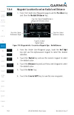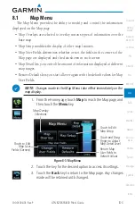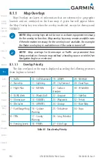
8-2
GTN 625/635/650 Pilot’s Guide
190-01004-03 Rev. P
Map
When greater than 15 knots ground speed the map is oriented either
north up with ownship oriented to its current track or track up. When less
than 15 kts ground speed, the directional ownship icon is replaced with a
non-directional icon because it can't be determined if the rotorcraft is going
sideways or backwards. The map will continue to orient to the current track if
the map is selected for Track Up. If the map is oriented to track up, then below
5 kts ground speed the map orientation will "latch" to the last valid track prior
to the ground speed going below 5 kts. The map will reorient when the ground
speed again exceeds 5 kts. The position of the ownship icon over the map is
always the current GPS position of the aircraft.
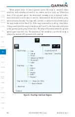
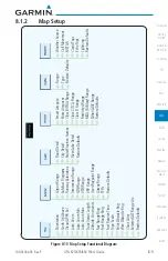
Graphically Edit FPL
Map Pointer - Create Wpt
Topo
Airways
Terrain
NEXRAD (or PRECIP)*
Stormscope*
Traffic*
Map Overlays
Map Detail
* Optional
Map
Aviation
Land
Airspace
Traffic*
Weather*
Map Setup
Map User Fields
Change User Fields
Restore Defaults
Figure 8-2 Map Page Functional Diagram
Summary of Contents for GTN 625
Page 608: ...This page intentionally left blank ...
Page 609: ......
Page 610: ...190 01004 03 Rev P ...

