Garmin G1000 Pilot’s Guide for the Piper PA-32 Saratoga
190-02692-00 Rev. A
270
HAZARD AVOIDANCE
SY
STEM
O
VER
VIEW
FLIGHT
INSTRUMENTS
EIS
AUDIO P
ANEL
& CNS
FLIGHT
MANA
GEMENT
HAZARD
AV
OID
ANCE
AFCS
ADDITIONAL FEA
TURES
APPENDICES
INDEX
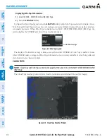
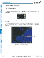
Figure 6-6 NEXRAD Weather Product at a 30 NM Map Range
Block Area is 4 km
2
The following may cause abnormalities in displayed NEXRAD radar images:
Ground clutter
Strobes and spurious radar data
Sun strobes (when the radar antenna points directly at the sun)
Interference from buildings or mountains, which may cause shadows
Metallic dust (chaff) from military aircraft, which can cause alterations in radar scans
neXraD l
imitations
(C
anaDa
)
Radar coverage extends to 55ºN.
Any precipitation displayed between 52ºN and 55ºN is displayed as mixed regardless of actual precipitation
type.
Below 52ºN, if the type of precipitation is unavailable, the system displays the precipitation using the
color codes associated with rain.


