


190-02692-00 Rev. A
Garmin G1000 Pilot’s Guide for the Piper PA-32 Saratoga
159
FLIGHT MANAGEMENT
SY
STEM
O
VER
VIEW
FLIGHT
INSTRUMENTS
EIS
AUDIO P
ANEL
& CNS
FLIGHT
MANA
GEMENT
HAZARD
AV
OID
ANCE
AFCS
ADDITIONAL
FEA
TURES
APPENDICES
INDEX
SYMBOL SETUP
All navigation maps can display land, aviation, airspace and airway symbols. Symbol types (e.g. runway
extensions, railroads) can be removed individually. The range sets the maximum range at which items appear
on the display. For example, enabling “Runway Extension” displays a dashed line on the map extending from
each runway of an airport in the flight plan when the range is set at or below the value of the map settings
option.
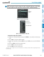
Displaying/removing all land symbols:
1)
Press the
MENU
Key with the MAP – NAVIGATION MAP Page displayed. The page menu is displayed and the
cursor flashes on the ‘Map Setup’ option.
2)
Press the
ENT
Key. The MAP SETUP Window is displayed.
3)
Highlight the LAND DATA Field.
4)
Select ‘On’ or ‘Off’.
5)
Push the
FMS
Knob to return to the MAP – NAVIGATION MAP Page.
The label size (TEXT) sets the size at which labels appear on the display (none, small, medium, and large).
The range (RNG) sets the maximum range at which items appear on the display.
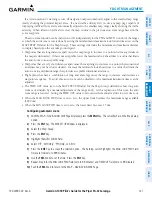
Selecting a ‘Land’ or ‘Aviation’ Group item text size and range:
1)
Press the
MENU
Key with the MAP – NAVIGATION MAP Page displayed. The cursor flashes on the ‘Map Setup’
option.
2)
Press the
ENT
Key. The MAP SETUP Window is displayed.
3)
Select the ‘Land’ or ‘Aviation’ Group.
4)
Press the
ENT
Key. The cursor flashes on the first field.
5)
Select the desired land option.
6)
Select the desired text size.
7)
Press the
ENT
Key to accept the selected size.
8)
Select the desired range.
9)
Press the
ENT
Key to accept the selected range.
10)
Push the
FMS
Knob to return to the MAP – NAVIGATION MAP Page.


