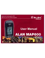


MAP 600 – User’s Manual
Page 6
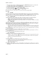
3. Description of MAP 600
3.1 Buttons and controls
3.1.a
Front Panel
1.
Integrated GPS antenna
– to receive signal from GPS satellites. For an optimal reception, the antenna should
be pointed towards the sky with an angle of approx. 45 degrees.
2.
LCD display (liquid crystal) –
to display different pages (screens), command menus, and operating modes.
3.
button (menu) –
to access to the command menu available for each page (screen) of the receiver, and for
programming of various functions.
4.
button (on/off-backlighting) – i
t provides with two functions:
•
by holding down the button for at least 2 seconds, the receiver turns on/off
•
when the receiver is turned on, a briefly pressure of the button activates and deactivates the display
backlighting
5.
button (pages/exit) –
to select the main pages (screens) and going backwards through the command
menus without creating or changing settings.
6.
direction Joystick –
to use different functions, such as scrolling through maps on the screen, moving the
position pointer, etc.
7.
and buttons (zoom) –
to, respectively, enlarge and reduce the maps scale
8.
button
(confirm) – to confirm the selected commands in the menu
3.1.b
Back Panel and Connections
9.
Threaded junctures
– to mount on the bracket
10.
Data socket
(on the bottom of the receiver, under the protective cap) – to connect to a PC via the DL500 serial
cable (or the US500 USB cable) in order to download maps, download/upload data and acquiring position by
NMEA standard.
11.
3V Max socket
(on the bottom of the receiver, under the protective cap) - 3VDC socket for the MAP600 power
supply and the Ni-MH batteries charge using the DC cable adapter (option).
12.
Lever on battery well cover
– to access to the battery well.
6
4
1
3
5
8
2
7
14
10
11
13
9
12
Summary of Contents for MAP600
Page 1: ......


