12-Locate & Mark Mode
Noggin
56
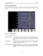
12.2 Scanning Screen
After pressing the Scan button, wait a few seconds for the vertical depth scale to appear on the
right side of the screen, and then move the GPR system forward.
A cross-sectional image of the ground scrolls onto the screen from the right to left. The position is
displayed on the horizontal axis at the top while the depth is displayed on the vertical axis. The
position and depth axes units are meters or feet depending on the units set in the Systems
Setting Screen (
Section 12.1.3
).
If the
Scale
or
Both
option is selected (
Section 12.1.3
), horizontal depth lines appear on the
image to assist with determining the depth of targets.
Approximately 16 meters or 50 feet of data is displayed on one screen. If the survey line exceeds
this distance the image will scroll off the left side of the screen.
Содержание Noggin 100
Страница 1: ...User s Guide Copyright 2012 Sensors Software Inc 2011 00022 02 Noggin ...
Страница 2: ......
Страница 4: ......
Страница 8: ......
Страница 17: ...Noggin 2 Noggin Components 3 Figure 2 3 Noggin 100 components ...
Страница 156: ...Appendix D Instrument Interference Noggin D 2 ...
Страница 158: ...Appendix E Safety Around Explosive Devices Noggin E 2 ...
Страница 162: ...Noggin G 4 ...

