
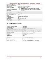


GALILEOSKY GLONASS/GPS Satellite v4.0 (0223) User’s manual
GalileoSky Ltd.
Page 17
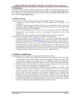
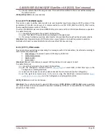
Latitude and longitude values are entered through the point “.” (For example: 57.9842) where the value
after point – is degree fractions. To transfer minutes into degree fractions (Xdegr.Ymin.) use the following
expression Xdegr. = Ymin./60. For example: 57 degr. 55.4513min = 57.924188 degr.
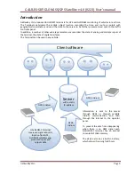
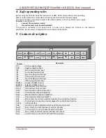
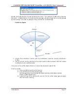
Explanatory diagram
3.
Activate the autoinformer function with the Autoinformer command. (section Autoinformer
setting).
4.
Insert a micro-SD card into the Terminal and reset it with the Reset command. After the Terminal
resetting the function will be activated.
In the process of sound files playback there is a 5 seconds pause between adjacent files.
To test sound files:
1)
Unscrew GLONASS aerial from the Terminal;
2)
Enter into file BusLine.txt the following lines:
[the following format: LAT,LON,ANGL,DELTA,RAD_EXT,RAD_INT,STRING_STATION]
0.0;0.0;12.0;180;500;0;TEST.wav
3)
Create
TEST.wav.
file in the micro-SD card root. This file will be played again and again
after the Terminal resetting.
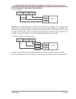
∆
Sound file zone
coordinate
α
Meridian
Rext
Rint
Direction
Sound file zone


