S2E-17-0209_IM_WR2120_C
35
Note
: Elevation angle written here is one example. It depends on geographical feature where radar is
located. For another example, if it is in a flat country like Denmark, a water tower in Lund, and
Sweden, it used -1 degree, 10 km range and was able to detect coastline and the city boarders of
Copenhagen.
1) Click [STBY] in [Radar operation] to Stop TRX.
2) Add a map file to RainMap and display on screen (or use other PC to see a map).
3) Locate a characteristic geographical feature like a mountain line ridge or form, note distance, and
relative bearing on map.
4) Set radar to a higher elevation until no echo is received from lower buildings or structures, possibly
5 degrees (in some cases 3 to 7 degrees may be required) in RainMap.
5) Set a distance to more easily confirm the geographical feature “6)” in “Range [km]” in [View]
setting menu of RainMap.
6) Setup “Reflective Intensity [H]” in “DataType” using [View] setting menu of RainMap.
7) Confirm echo after starting [TX] from [Radar operation]. Purple observations indicate strong
echoes that may be from mountains.
8) Click [STBY] in [Radar operation] before making any changes to setting. To change “Azimuth
Offset” angle in [RDR Parameter] service menu of RainMap, compare shape of echo with “6)” and
“10)”. Echo indication will be rotated clockwise if a large value entered in “Azimuth Offset”.
(Available range: -360 to 360)
9) Repeat steps “10)” to “11)” until an echo aligns with the geographic feature
10) Click [STBY] in [Radar operation] after finished “12)”.
11) Set 0 degree at [Elevation] in [View] setting menu of RainMap.
12) Set a distance suitable for the area at “Range [km]” in [View] setting menu of RainMap.
13) Select “Rainfall Intensity” at [DataType] in [View] setting menu of RainMap.
14) Finish setup.
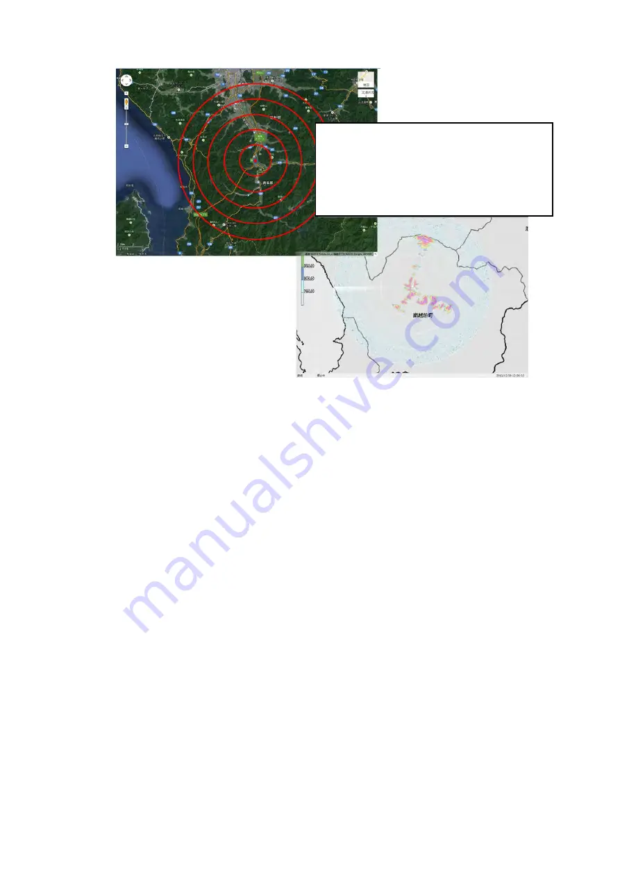
<Image screen>
Zh echo
Elevation 5 degree
Range 10km
No.32 P0N transfer
GCR OFF
1. Setup antenna elevation up to 5 degrees.
2. Ensure only the higher mountain radar
echoes are displayed exclude surrounding
buildings.
3. Determine correct echo indication azimuth
using echo characteristics and mountain
location on map.
Содержание 9ZWWR2120
Страница 1: ...S2E 17 0209_IM_WR2120_C i INSTALLATION MANUAL MODEL WEATHER RADAR TYPE WR2120 www furuno com...
Страница 44: ...S2E 17 0209_IM_WR2120_C 2 8 OUTLINE DRAWING 1 Antenna Unit...
Страница 45: ...S2E 17 0209_IM_WR2120_C 3 2 Signal Processing Unit Storage box...
Страница 46: ...S2E 17 0209_IM_WR2120_C 4 4 Data Processing Unit...
Страница 47: ...S2E 17 0209_IM_WR2120_C 5 5 Data Processing Unit DPU Power Supply...
Страница 49: ...S2E 17 0209_IM_WR2120_C 7 WR2120 Configuration...


