Leaders in Pipelin
e Survey Systems
C
C
C
-
-
-
S
S
S
C
C
C
A
A
A
N
N
N
2
2
2
0
0
0
1
1
1
0
0
0
SYSTEM MANUAL Version 6.03i
62
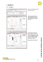
Survey 1 (S#00)
Data
Point
Current Depth
Latitude
Longitude
Distance
Chainage Attenuation
#00 163.4
4.23
44N29.534'
012W02.850' 0.0 0.0 0.00
#01 156.6
4.07
44N29.485'
012W03.050' 918.6 918.6
0.13
#02 88.52
4.30
44N29.467'
012W03.150' 446.2 1364.8
3.64
#03 85.91
4.04
44N29.440'
012W03.300' 672.6 2037.4
0.13
#04 85.38
3.41
44N29.430'
012W03.384' 367.5 2404.9
0.05
#05 55.91
4.07
44N29.424'
012W03.539' 672.6 3077.4
1.79
#06 52.64
3.64
44N29.424'
012W03.700' 698.8 3776.2
0.25
Survey 2 (S#01)
Data
Point
Current Depth
Latitude
Longitude
Distance
Chainage Attenuation
#07 415.5
6.27
44N29.534'
012W02.850' 0.0 0.0 0.00
#08 21.44
5.25
44N29.485'
012W03.050' 918.6 918.6
9.20
#09 13.64
5.81
44N29.467'
012W03.150' 446.2 1364.8
2.89
#10 10.44
5.15
44N29.440'
012W03.300' 672.6 2037.4
1.13
#11 9.97
6.43
44N29.430'
012W03.384' 367.5 2404.9
0.36
#12 5.79
5.61
44N29.424'
012W03.539' 672.6 3077.4
2.30
Survey 3 (S#02)
Data
Point
Current Depth
Latitude
Longitude
Distance
Chainage Attenuation
#13 30.00
2.99
44N29.534'
012W02.850' 0.0 0.0 0.00
#14 21.44
5.25
44N29.485'
012W03.050' 918.6 918.6
1.04
#15 13.64
5.81
44N29.467'
012W03.150' 446.2 1364.8
2.89
#16 10.44
5.15
44N29.44' 012W03.300' 672.6 2037.4
1.13
#17 9.97
6.43
44N29.43'
012W03.384' 367.5 2404.9
0.36
#18 5.79
5.61
44N29.424'
012W03.539' 672.6 3077.4
2.30
Survey 4 (S#03)
Data
Point
Current Depth
Latitude
Longitude
Distance
Chainage Attenuation
#19
400
3.22
Choose
#20
380
3.94
Choose
#21
360
9.84
Choose
#22
300
11.48
Choose
#23
290
9.88
Choose


