Leaders in Pipelin
e Survey Systems
C
C
C
-
-
-
S
S
S
C
C
C
A
A
A
N
N
N
2
2
2
0
0
0
1
1
1
0
0
0
SYSTEM MANUAL Version 6.03i
70
11.4.2. GPS Functions
DCAPP has the ability to fix surveys with missing or incorrect GPS data, or adjust surveys
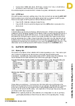
based on the GPS data that was recorded. To correct any GPS data, click on
CHECK
GPS
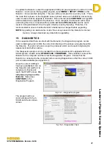
from the START-UP screen to access the following window:
Fig 11.12 – GPS correction screen
•
Re-sequence Points from GPS - When saving points during a survey, the distance
can be entered manually or GPS data can be
used to calculate the distance. Even if the
distance is entered manually, the GPS location is
saved, if available. If any manually entered point
is subsequently found to be erroneous, then it can
be corrected using the GPS data.
•
Force Chainage to GPS
- When re-sequencing points from the GPS data,
you can force the chainage of a survey to take its
distances based on the GPS separation rather
than manually entered distances.
•
Interpolate/Extrapolate
GPS - GPS points can be added where no data exists:
−
Generate Missing GPS only
- If a gap in the GPS data exists (GPS was off/view
of satellites obstructed) then DCAPP can
interpolate the data and add missing GPS points.
−
Re-Generate GPS from
Suppressed Points ONLY
- GPS data will be re-calculated but only for points
that have been suppressed in the
Table
view (see
8.2-2, above). I.e. If GPS data exists but seems
incorrect, the data can be re-calculated by
suppressing the point or points in the table and
using this function. All other points will remain
unchanged.
−
Generate ALL Points from
Chainage
- Using this function will assume that the start point
GPS data is correct and then calculate GPS
points based on the chainage distances manually
entered by the user during the survey.
NOTE:
GPS always assumes the distance between two points is based on a straight line,
which may not always be the case. See
Notes on Entering Distances
section 6.6.

