


Leaders in Pipelin
e Survey Systems
C
C
C
-
-
-
S
S
S
C
C
C
A
A
A
N
N
N
2
2
2
0
0
0
1
1
1
0
0
0
SYSTEM MANUAL Version 6.03i
16
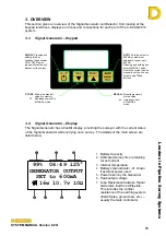
3.3. Signal Generator – Side Panel
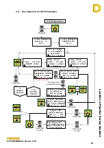
3.4. Detector Unit – Front Panel
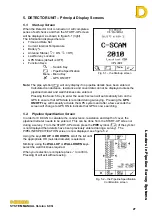
The C-SCAN 2010 is the next generation design in the 2000 series Pipeline Survey
System. The system increases the speed and accuracy and includes more statistical
features for noise reduction, including:
•
Built in Global Positioning System (GPS) unit for precision position indication.
•
Attenuations can be calculated using GPS position information
•
Full graphic interface allows the displaying of data without the use of a laptop or PC.
The onboard search facility displays:
1. Pipeline position
2. GPS coordinates
3. Depth/Cover indicator
4. Pipeline diameter
5. Survey and location number
6. Facility for recording pipeline
diameter and wall thickness.
7. Display of approximate coating
conductance in
μ
S/m
2
.
8. Display of approximate coating
resistance in
Ω
m
2
9. Symbol inclusion for landscape
features
10. Graphs include:
Attenuation
– by chainage or
increment
Depth
– cover or to centre line
Current
– including
close interval
plots
GPS plot
– show the plan of the
pipeline
•
Full compatibility with
DCAPP for Excel
included in C-SCAN 2000
•
Software upgradeable via PC
Connection to
suitable EARTH
Connection to
PIPELINE
CHARGER or AUXILIARY
power connector
USB Diagnostic /
Upgrade port
BATTERY
isolator switch.