Leaders in Pipelin
e Survey Systems
C
C
C
-
-
-
S
S
S
C
C
C
A
A
A
N
N
N
2
2
2
0
0
0
1
1
1
0
0
0
SYSTEM MANUAL Version 6.03i
40
6.6. Notes on Entering Distances
The distance that is entered is crucial to calculating the correct attenuation; hence it is very
important that this value is correct. Remember that the distance entered relates to
pipeline
distance, not the direct distance between two points.
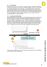
If two successive points are taken around a bend in a pipeline and GPS is being used, it is
important to enter the
pipeline distance
and NOT use the GPS distance, as this will cause
an error. GPS will only calculate the straight line distance between two points.
The table below shows the error for two readings
taken 165ft either side of a bend when comparing the
direct line that would be calculated by GPS versus the
actual pipeline distance. The increase in error can be
seen with the increase in angle, as demonstrated
below.
Bend angle
Pipeline Distance
Direct dis tance
% error
0
328
328
0
10
328
328
0
20
328
322
1
30
331
318
3
40
335
308
7
50
338
299
11
60
341
285
16
70
344
269
21
80
348
253
27
90
351
233
33
6.7. Chainage
Chainage is the term given to incremental distance from the survey
Start Point
, i.e. the
distance between a survey point and the Start Point of the survey, rather than the previous
point. As an example, a survey has 4 points taken 100m apart. While the distance
entered relates to the previous survey point, the chainage relates to the Start Point of the
survey:
Point Distance
Chainage
#00 0 0
#01 300 300
#02 300 600
#03 300 900
This can make it easier to reference if CP points have distance values already assigned to
them. To use chainage rather than distance, use the chainage key as shown below.
Fig. 6.13 – GPS distance


