

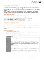


The
Dashboard
tab with an example flight is shown below:
You must use the Aerial Imaging software on the tablet to monitor the rover during the entire flight:
l
The trajectory of the rover on the map must be close to the programmed flight path.
l
Monitor the level of power in the rover battery. In the battery status bar
, the value is expressed as
a percentage and as time remaining in minutes.
l
Monitor the flight time
. The value is expressed as the flight time remaining and as the flight time
done, both in minutes.
l
Monitor the number of flight lines flown against the total number of flight lines
.
l
Monitor the strength of the communication link
.
l
Monitor the number of usable satellites
.
l
No signal: No GPS lock (0–3 satellites)
l
1 signal line: 4–6 satellites
l
2 signal lines: 7 or more satellites
l
Monitor that the number of eBox feedback events increases as expected
.
l
Monitor the wind speed and direction measured by the eBox
.
l
Compare the actual airspeed with the desired airspeed
, which is 85 kph (53 mph) during cruise
flight. The actual airspeed can be higher than the desired speed when the UX5 HP is coping with a high
head wind. The maximum airspeed is 90 kph (56 mph).
l
Monitor the ground speed
.
l
Monitor the distance between the GCS and the aircraft, projected perpendicular onto the GCS
reference plane, and the azimuth from the GCS to the aircraft
.
l
Compare the actual flight height
with the desired flight height set during block and flight planning.
85
Delair-Tech
|
676, Rue Max Planck – 31670 Toulouse-Labège, France
|
Tel: +33 (0) 5 82 95 44 06
|
Capital: 238 110,30 € - APE: 3030Z – Intra-Community VAT number: FR90 53 09 69 781 – 530 969 781 R.C.S. Toulouse
This document is the sole property of Delair-Tech and cannot be used or reproduced without the written authorization of Delair-Tech
.


