

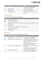


To change the status of a layer, select a layer in the list and then toggle the buttons above the list:
Click...
To make the layer...
/
Visible / hidden
/
Unlocked / Locked (not editable)
This button is available only for avoidance zone layers.
To remove a layer that is no longer required, select the layer in the list and then click
below the list. You
cannot delete the online map layer and you cannot delete the master map if it is the only georeferenced
map available.
To rename a layer, select the layer in the list and then click the layer's name. You can now edit the name.
The online map cannot be renamed.
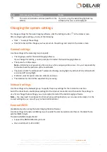
Click the appropriate icon to toggle between the satellite view
, the road view
, and the terrain view
of the online map. (Google Maps only).
Use the
and
buttons to zoom in and zoom out of the map.
Click
to display the map grid lines.
Use the
button to zoom the map and all of its layers to the best view.
If you are viewing the map on the tablet and it has a GPS connection, the
button is available. If you pan
around the map, click
to center the map on the current GPS location.
During flight, the
button is available. Click
to center the map on the current rover location.
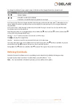
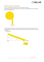
Defining the blocks
A block is the area to be flown over at a specified ground sample distance (GSD) and image overlap.
A project needs at least one block. To define blocks, select the
Blocks
tab.
Note –
You must validate in the field any blocks you have defined in the office.
27
Delair-Tech
|
676, Rue Max Planck – 31670 Toulouse-Labège, France
|
Tel: +33 (0) 5 82 95 44 06
|
Capital: 238 110,30 € - APE: 3030Z – Intra-Community VAT number: FR90 53 09 69 781 – 530 969 781 R.C.S. Toulouse
This document is the sole property of Delair-Tech and cannot be used or reproduced without the written authorization of Delair-Tech
.


