


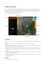


Rally Point:
The Rally icon shows the location of your planned Rally points. The icon is a flag within a triangle.
Flight Leg:
The flight legs connect each waypoint in sequence. They are an approximate indication of how the aircraft will fly
from one waypoint to the next. They do no account for the turning radius of the aircraft. It is normal to observe small deviations
from the flight legs in windy conditions.
Circle Radius:
A dashed line will appear around certain waypoints that have a radius. Examples include the landing pattern and
loiters.
Home:
Displays the home location. Home is your takeoff location.
Waypoints:
Displays the location of your planned waypoints. Each waypoint is numbered. Waypoints are used to fly to a
location in the sky. The aircraft will fly through or near the waypoint and then proceed to the next item in your mission.
Waypoints are automatically generated when creating a survey.
S urvey Polygon:
A survey polygon displays the area on the ground that you are mapping. Survey polygons are created from the
Plan
tab
⇨
Survey
. You can draw a new region or load a KM L or KM Z (Google Earth format). Flight legs will extend past the
polygon area to account for the extra space that the aircraft needs to turn around. Viewing the polygon can be toggled on/off from
the
Layers
button
⇨
Survey
. M ultiple survey areas can be planned into your mission.
Aircraft Trail:
The aircraft trail shows the history of the aircraft’s flight path. At a certain length, the trail will automatically begin
to disappear. The trail can also be clear manually from the
Layers
button
⇨
Clear Aircraft Trail
.
Aircraft:
Displays the aircraft location and heading.
GCS Overview
25
Summary of Contents for Lynx VTOL
Page 6: ...Package Contents Package Contents 6...
Page 18: ...3 Right click on the USB Serial Port and select properties Getting Started 18...
Page 19: ...4 Swap to the Port Settings tab and select Advance Getting Started 19...
Page 86: ...Landing 86...
Page 87: ...Payloads Standard Mapping Payload Multispectral Mapping Payload Custom Payloads Payloads 87...
Page 94: ...Standard Mapping Payload 94...
Page 108: ...Mounting Custom Payloads 108...
Page 110: ...Post Processing Geo Tagging PPK Tagging Base Station Reference Stations Post Processing 110...
Page 114: ...Geo Tagging 114...
Page 130: ...Battery Charging Charging Storage Battery Management 130...
Page 136: ...Second Battery Start Charging 136...
Page 143: ...Second Battery Start Storage 143...
Page 149: ...Replacing the Main Propeller 149...
Page 167: ...Getting Logs 167...
Page 171: ...2019 02 11 Ensure the landing checklist matches the GCS landing checklist Manual Changelog 171...


