


v1.32
March 2014
83 of 90
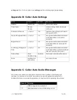
TTF: This is the amount of time required to acquire a position. For collars and pod
shipped after March 2, 2009 this column is the time required to acquire a position plus the
GPS additional time.
Latt: Latitude
Long: Longitude
Altitude: Altitude, please note that this will not be very precise, your maps will have
more precise altitude data
Maxsnr: Maximum satellite signal strength
HDOP: Horizontal dilution of precision
VDOP: Vertical dilution of precision, no data will be displayed for this model/
Satt: The number of satellites acquired before the GPS module wrote the position to
memory. This includes satellites acquired during the GPS Additional Time.
Fix: No means that there was no location acquired. 2D means that it was a two
dimensional location, 3D means that it was a three dimensional location.
V1: The GPS battery voltage at the time the location was recorded. If no GPS position is
recorded this voltage reading can be incorrect.
T1: The temperature at the time the location was recorded. If no GPS position is
recorded this temperature reading can be incorrect.
Speed (km/h): Velocity measured in kilometers per hour.
Speed (miles/h): Velocity measured in miles per hour.
Heading (degrees): Heading demonstrated in degrees.
Summary of Contents for 4000 Enhanced
Page 90: ...v1 32 March 2014 90 of 90...


