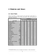

4 Modules and Views
4.1 Data Fields
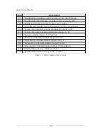
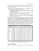
Table 4.1 provides a complete reference for what kind of data fields (i.e.
satellite data) gpredict can calculate, and which views and functions can
show them to the user.
Data Field
Available in
List
View
Map
View
Polar
View
Single
Sat.
Predict
dial.
Satellite Name
-
√
√
√
√
√
Catalogue Number
-
√
√
Azimuth
[°]
√
√
√
√
Elevation
[°]
√
√
√
√
Direction
-
√
√
√
Right Ascension
[°]
3
√
√
√
Declination
[°]
√
√
√
Range
[km]
√
√
√
Range Rate
[km/s]
√
√
√
SSP Latitude
[
°
]
√
√
√
√
SSP Longitude
[
°
]
√
√
√
√
SSP Maidenhead Locator
-
√
√
√
√
Footprint
[km]
√
√
√
√
Ground Track
-
√
Sky Track
-
√
Altitude
[km]
√
√
√
Velocity
[km/s]
√
√
√
Doppler Shift (100 MHz)
[Hz]
√
√
√
Signal Loss
[dB]
√
√
√
Signal Delay
[ms]
√
√
√
Mean Anomaly
[
°
]
√
√
√
3 The right ascension can also be displayed in hh:mm:ss or hh:mm.mm format.
31


