background image

6

Getting Started

Power On/Screen Contrast

GPSMAP 182/232 Getting Started Tour

The GARMIN GPSMAP 182/232 is a powerful electronic navigation system that provides detailed 

map coverage and convenient control of many advanced features right from the screen display. This 
tour is designed to take you through the basic pages and functions of the system using the simulator 
mode. Once you’re familiar with the main pages and functions of the unit, refer to the reference section 
for instructions on performing specifi c tasks and functions.

The Getting Started Tour assumes that the receiver has been properly installed and initialized, 

and you have not changed any of the default unit settings. If you have changed any settings (position 
formats, units of measure, etc.), the descriptions and pictures in the tour may not match your 
confi guration.

To turn the GPSMAP 182/232 on:

1.   Press and hold the 

POWER 

key until the power tone sounds, then release the 

POWER 

key. The 

Warning Page will appear while the unit conducts a self-test.

2.   Once the self-test is complete, press the 

ENTER/MARK 

key, if you agree, to acknowledge the 

warning.

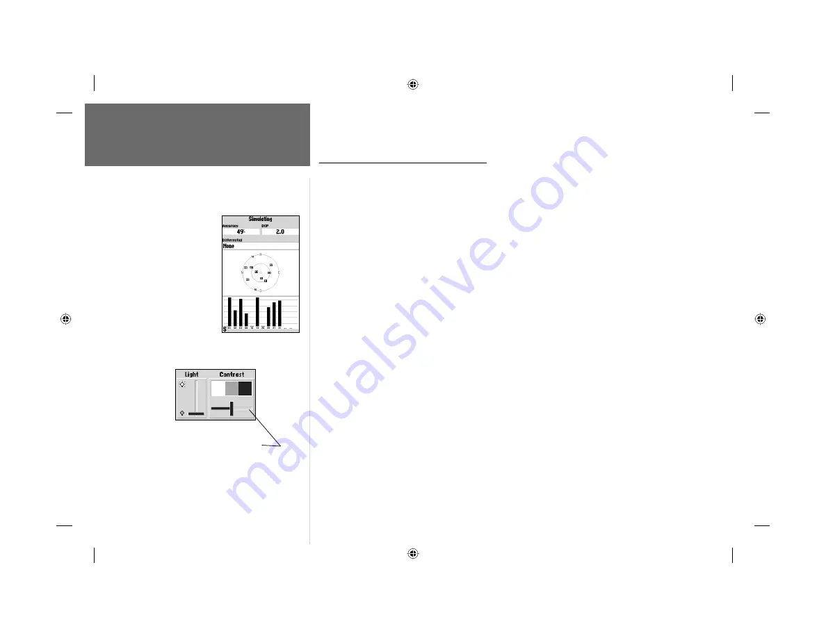
The GPS Information Page will appear as the receiver begins acquiring satellites. From this or any 

other page, you may also adjust the screen contrast and backlighting.

To adjust the screen contrast:

1.   Press 

POWER 

and the Light and Contrast window will appear.

2.   To decrease or increase the screen contrast, press left or right on the 

ARROW KEYPAD

.

3.   Press the 

ENTER/MARK 

key to fi nish.

The GPSMAP 182/232’s adjustable screen backlighting is controlled with the 

POWER

 key, and 

may be adjusted at any time from any page. The backlight can cycle through off, user-defi ned, and 
maximum backlight levels by repeatedly pressing the 

POWER

 key.

To adjust the screen contrast, 
press 

LEFT

 or 

RIGHT

 on 

the 

ARROW KEYPAD

 to 

move the contrast slider.

A full-screen GPS Information 
pop-up page is displayed after 
you press the 

ENTER


key 

to acknowledge the Warning 
Page. The pop-up page will go 
away after the unit gets a posi-
tion fi x or you press either 

ENTER

 or 

QUIT

. The page 

can be disabled and enabled on 
the Pages Tab (see page 61).

182_232 Manual Part 1.indd

12/21/01, 11:43 AM

6

Summary of Contents for GPSMAP 182

Page 1: ...owner s manual and reference guide chartplotting receiver GPSMAP 182 shown GPSMAP 182 232 182_232cover indd 12 21 01 11 39 AM 1...

Page 2: ...red in any storage medium for any purpose without prior written consent of GARMIN GARMIN hereby grants permission to download a single copy of this manual onto a hard drive or other electronic storage...

Page 3: ...ences to the advanced features and operations of the GPSMAP 182 232 This allows you to concentrate on a speci c topic quickly and look up detailed information about the GPSMAP 182 232 Customer Service...

Page 4: ...erence and 2 this device must accept any interference received including interference that may cause undesired operation This equipment generates uses and can radiate radio frequency energy and if not...

Page 5: ...ITY ARIS ING UNDER ANY WARRANTY OF MERCHANTABILITY OR FITNESS FOR A PARTICULAR PUR POSE STATUTORY OR OTHERWISE THIS WARRANTY GIVES YOU SPECIFIC LEGAL RIGHTS WHICH MAY VARY FROM STATE TO STATE IN NO EV...

Page 6: ...pact plastic alloy case waterproof to IEC 529 IPX 7 Advanced Navigating and Plotting 3000 alphanumeric waypoints with selectable icons and comments Built in Worldwide basemap to 20 miles includes deta...

Page 7: ...Quick Reference Card Protective Cover Not included with part numbers 010 00238 01 with internal bail mount antenna Not included with part numbers 010 00238 00 or 010 00250 00 with external antenna Op...

Page 8: ...8 Highway Page and Options 28 Waypoints 30 Creating 30 Reviewing and Editing 32 Proximity 35 Going to a Destination 37 TracBack 38 MOB 40 vii Introduction Table of Contents Routes 41 Creating 41 Revie...

Page 9: ...t s function keys 1 Mark your present location as a waypoint 10 30 Go to a destination 11 14 37 38 Create and use a route 41 47 Learn about the Map page 8 9 18 19 Pan using the map arrow 9 19 20 Zoom...

Page 10: ...ta entry MENU Key The MENU key displays a menu of available options for the current page Press twice to display the Main Menu ARROW KEYPAD The ARROW KEYPAD is used to select Highlight menu options and...

Page 11: ...d box on a page 2 Use the ARROW KEYPAD to move the cursor highlight up and down a list or up down and sideways on menus 3 Once you have moved to the selection desired press the ENTER MARK key to eithe...

Page 12: ...keypad moves you rapidly through the list 4 Use the ARROW KEYPAD LEFT RIGHT arrows to move to the next character on the line or backwards to edit characters If there are more than two lines of data k...

Page 13: ...tialization the GPSMAP 182 232 is shipped from the factory in AutoLocate mode which will allow the receiver to nd itself anywhere in the world To speed up the initialization process we recommend using...

Page 14: ...ady 2D or 3D during this process it is not necessary to initialize the unit The GPSMAP 182 232 will now begin searching for the appropriate satellites for your region and should acquire a x within a f...

Page 15: ...le the unit conducts a self test 2 Once the self test is complete press the ENTER MARK key if you agree to acknowledge the warning The GPS Information Page will appear as the receiver begins acquiring...

Page 16: ...Press Up or Down on the ARROW KEYPAD until the GPS tab is highlighted then press the MENU key once 2 Use the UP or DOWN arrow of the ARROW KEYPAD to highlight the Start Simulator option and press ENTE...

Page 17: ...ures and displays The map display shows your boat as a triangle marker on an electronically generated chart Geographic names roads markers and buoys that are provided by the optional BlueChart or MapS...

Page 18: ...ong with the latitude longitude of the cursor 3 Press the QUIT key to remove the cursor and re center your boat on the map display As you become more familiar with the cursor you ll see that the map d...

Page 19: ...to where you left off 5 After you have entered all the letters press ENTER MARK to con rm the name 6 To access the waypoint symbol page highlight the waypoint symbol eld which is to the left of the w...

Page 20: ...re going to select a pre programmed tour route using the rst method This will also show how the MENU key is used throughout the GPSMAP 182 232 system to provide tab style options and functions Let s...

Page 21: ...A data eld at the top of the page will now display the speed distance to the second route waypoint your position coordinates and a compass ribbon which shows you which way to go To get started let s e...

Page 22: ...from your present position and the coordinates for the waypoint To review the waypoint page for a selected waypoint 1 Press the ENTER MARK key 2 To return to the Map Page press ENTER MARK again or pre...

Page 23: ...f the screen This page provides better steering guidance when travelling at slower speeds and or when making frequent directional changes When you are not navigating to a waypoint the compass will sho...

Page 24: ...navigation point Use the Highway Page as your primary navigation page in lieu of the Compass Page when your main concern is following a de ned course Whenever the GPSMAP 182 232 is in simulator mode y...

Page 25: ...Whenever you have activated a route or Follow Track this page will show each waypoint name along with useful data for each point As you navigate the route the information will automatically update to...

Page 26: ...he Dock waypoint also Congratulations You ve now gone through the basic operation of the GARMIN GPSMAP 182 232 Your new digital chartplotter is a powerful tool with many advanced features not covered...

Page 27: ...e the cursor Two basic map operating modes position mode and cursor mode determine what cartography is shown on the map display Position mode pans the cartography to keep the present position marker w...

Page 28: ...will be displayed in the data window along with the cursor s position coordinates Keep in mind that when the cursor is stationary the distance and bearing from your present position will change as yo...

Page 29: ...e OUT key to zoom out and the IN key to zoom in The scale value represents the distance from one end of the scale bar to the other The GPSMAP 182 232 s system has a built in worldwide database to 20 m...

Page 30: ...GPSMAP 182 232 s Map Page provides access to functions and features relating to the Map Page and the layout options To display the Map Page options 1 Press MENU To select a menu option 1 Use the ARROW...

Page 31: ...bbon COURSE Desired Track DEPTH Depth below transducer if receiving proper sonar NMEA data from other device DIST TO DESTINATION Distance to nal waypoint DIST TO NEXT Distance to next waypoint ELEVATI...

Page 32: ...e highlight the data eld you want to change and press MENU 2 Choose Split Number or Merge Numbers then press ENTER MARK You will now see four new data elds or one large eld Press QUIT when done 3 To r...

Page 33: ...change and press ENTER MARK 3 Move UP or DOWN on the ARROW KEYPAD to highlight to the desired setting and press ENTER MARK To exit press QUIT General Tab Detail Most More Normal Less Least controls h...

Page 34: ...how None and press ENTER MARK 4 To display detailed information and notes for each area highlight the desired name and press ENTER MARK To view the notes for that area choose Show Notes To scroll thro...

Page 35: ...Lat Lon Grid Text None Small Medium and Large controls the screen size of the name Zoom Auto Off 120 ft 800 mi sets the maximum scale at which the feature should appear on the screen Map Outlines On...

Page 36: ...rection of your movement and the direction to your destination For instance if the arrow points up you are going directly to the waypoint If the arrow points any direction other than up turn toward th...

Page 37: ...bar in the middle The bottom section of the screen provides visual guidance to the waypoint on a graphic highway display The line down the center of the highway represents your desired track line As...

Page 38: ...display Use the ARROW KEYPAD and ENTER MARK key to select deselect the desired options Four options are available Active Route Waypoints all active route waypoints User Waypoints only nearby waypoint...

Page 39: ...the GPS tab on the Main Menu When you move the cursor over a map item you will see a highlighted description of that item You may also use this option to manually enter waypoint coordinates To mark yo...

Page 40: ...cription of that point and its distance and bearing from your current position To create a new waypoint graphically 1 Use the ARROW KEYPAD to move the cursor to the desired map position If you want to...

Page 41: ...ypoint Edit page you may change the name symbol comment position coordinates or depth for the selected waypoint Once the changes have been made highlight Next and press ENTER MARK to save them or pres...

Page 42: ...ccess the Main Menu Page Waypoint Points submenus 1 Press MENU twice then highlight the Points tab using the ARROW KEYPAD then highlight the desired submenu tab User Waypoint List The rst waypoint sub...

Page 43: ...ally highlight the next waypoint To delete an individual waypoint from the list 1 Use the ARROW KEYPAD to highlight the waypoint to be deleted and press MENU 2 Highlight Delete Waypoint and press ENTE...

Page 44: ...To select a waypoint from the lists use the ARROW KEYPAD to highlight the desired waypoint from the User or Nearest tab lists To select a waypoint from the map highlight either the User or Nearest tab...

Page 45: ...the list 1 Use the ARROW KEYPAD to highlight the proximity waypoint to clear and then press the MENU key 2 To clear a single alarm highlight the Delete Alarm option and press ENTER MARK 3 To clear al...

Page 46: ...list 4 To select a waypoint from the waypoint lists use the ARROW KEYPAD to highlight either the User or Nearest tab select a waypoint and press ENTER MARK To select a waypoint from the map highlight...

Page 47: ...press ENTER MARK TracBack Navigation Follow Track The second method of navigating to a destination is by using the TracBack or Follow Track feature The TracBack function allows you to retrace your pat...

Page 48: ...MARK 3 Choose either Original which will navigate you from the start to the end of your trip or Reverse which will navigate you from the end to the start of your trip and press ENTER MARK Once a Trac...

Page 49: ...GPSMAP 182 232 s Man OverBoard function MOB lets you simultaneously mark and set a course to a position for quick response to emergency situations To activate the MOB function 1 Press the MOB key 2 Pr...

Page 50: ...existing waypoint or map item to the route use the map cursor to highlight the desired waypoint or map item on screen and press ENTER MARK Map items will not appear in the waypoint list To create a w...

Page 51: ...u may also choose from other points such as Cities Tide Stations etc from this list From either the By Name or Nearest tab lists choose the waypoint you want and press ENTER MARK See page 35 for searc...

Page 52: ...ight the route you wish to navigate and press ENTER MARK 3 Choose Activate or Invert and Activate and press ENTER MARK Activate will use the route as is Invert and Activate will reverse the route then...

Page 53: ...KEYPAD to enter the desired name and press ENTER MARK when nished Once you are on the Route Review page you may review the route points waypoints or map items one at a time from the list To review in...

Page 54: ...y or adding turns to the beginning or end of the route To remove a route waypoint 1 Highlight the Remove option and press ENTER MARK To move a route waypoint 1 Highlight the Move option and press ENTE...

Page 55: ...he bottom of the list and press MENU 2 Highlight Add Before and press ENTER MARK 3 From the Find menu highlight Waypoints and press ENTER MARK You may also choose from other points such as Cities Tide...

Page 56: ...and select Trip Plan ning from the options list Enter the gures for Speed Fuel Flow Departure Time and Departure Date Press QUIT to return to the Route Plan Page Fuel ow rates on your unit are measure...

Page 57: ...ers see page 21 for instructions same as Map Page option Change Numbers see page 22 23 for instructions Edit on Map see page 45 for instructions Add Before see pages 45 46 for instructions Remove see...

Page 58: ...n 1 From any page press FIND 2 Using the ARROW KEYPAD highlight the desired category from the list and press ENTER MARK 3 For Waypoints and Cities you may search using By Name or Nearest Use the ARROW...

Page 59: ...ditional Information Any item you locate using the Find feature will also have additional information such as item classi cation distance bearing and coordinates data source etc depending on the type...

Page 60: ...on the ARROW KEYPAD to get back to the Menu tab list Press QUIT to return to the Main Menu page The Main Menu tabs are GPS shows satellite status accuracy initialize position Tide shows 24 hour tide c...

Page 61: ...ferential 3D or 3D Differential in the status eld The sky view shows a bird s eye view of the position of each satellite relative to the receiver s last known position The outer circle represents the...

Page 62: ...Receiver status is indicated at the top eld of the page with the current Accuracy and Dilution Of Precision DOP to the right of the sky view DOP is an indication of satellite geometry quality measured...

Page 63: ...WAAS is enabled and receiver is searching for WAAS signal Using WAAS WAAS capability enabled and unit receiving WAAS corrections No Beacon Signal DGPS receiver attached but not transmitting RTCM data...

Page 64: ...AutoLocate allows the receiver to locate your position automatically This process can take up to ve minutes Initialize Position allows you to initialize the receiver graphically on the Map Page to in...

Page 65: ...he top will indicate the time of day when using current date and will intersect the tide graph to show their relation The tide curve shows as a shaded area with higher tides being taller and lower tid...

Page 66: ...change the date to see tide charts for other days To change the date for the tide chart 1 Using the ARROW KEYPAD highlight the On eld and press ENTER MARK 2 Enter the desired date and press ENTER MARK...

Page 67: ...sired list or tab lists and press ENTER MARK For a location from the map choose Other Location and press ENTER MARK select a position on the map and press ENTER MARK 4 From the Find item detail page h...

Page 68: ...each saved log For the Active tab the following settings are available Record Mode lets you select one of three track recording options Off No track log will be recorded Note that selecting the Off se...

Page 69: ...e a TracBack from any of the saved tracks on this tab To activate a TracBack from the Saved tab list 1 Using the ARROW KEYPAD highlight the track you wish to use for a TracBack and press NAV 2 The Fol...

Page 70: ...er up screen To select deselect a main page 1 Use the ARROW KEYPAD to highlight the box to the left of the page name Pressing ENTER MARK will select deselect that page When a page is selected a 9 will...

Page 71: ...l Auto Track will steer to the current navigation point User Track allows you to enter a heading in the Track eld Speed lets you enter a speed Track lets you enter a heading Set Position allows to set...

Page 72: ...llows you to manually select the datum reference used to determine a given position The default setting is WGS 84 The unit will automatically choose the best datum depending upon your chosen position...

Page 73: ...Temperature lets you select the desired units of measure for temperature in Fahrenheit F or Celsius C Comm Communications tab lets you control the input output format used when connecting your GPSMAP...

Page 74: ...OW KEYPAD elect the desired setting and press ENTER MARK To select a transfer mode 1 Use the ARROW KEYPAD to select GARMIN Data Transfer in the Serial Data Format eld 2 Highlight the Transfer Mode eld...

Page 75: ...highlight Restart Scan and press ENTER MARK To manually enter a frequency and bit rate 1 With the unit set to GARMIN DGPS or RTCM In NMEA Out use the ARROW KEYPAD to highlight the Beacon eld and pres...

Page 76: ...off course alarm on and off Clock provides an alarm for the system clock Enter a time in the time eld and turn the alarm on and off from the control eld menu Remember to enter alarm times in the same...

Page 77: ...ceiver Position coordinates may be displayed as TDs and all navigation functions may be used as if the unit was actually receiving LORAN signals Using the LORAN TD Format When creating new waypoints u...

Page 78: ...tting and press ENTER MARK 4 When done press the QUIT key to return to the Main Menu If the active GRI Chain secondary stations or offsets have been changed since the waypoint was created the waypoint...

Page 79: ...07 5 to E022 5 1 E022 5 to E037 5 2 E037 5 to E052 5 3 E052 5 to E067 5 4 E067 5 to E082 5 5 E082 5 to E097 5 6 E097 5 to E112 5 7 E112 5 to E127 5 8 E127 5 to E142 5 9 E142 5 to E157 5 10 E157 5 to E...

Page 80: ...dealer or GARMIN Customer Service pg iv to have the unit serviced Lost Satellite Reception The unit has lost satellite signals Check antenna connections or try moving to a location with a clear view...

Page 81: ...from other device has more than 50 points Reduce number of points Running Simulator Unit is in simulator practice mode Track Already Exists track name You have entered a saved track name that already...

Page 82: ...sia Dos 1968 Dos 1968 Gizo Island New Georgia Islands Dutch Dutch Easter Isld 67 Easter Island 1967 European 1950 European 1950 Austria Belgium Denmark Finland France Germany Gibraltar Greece Italy Lu...

Page 83: ...ima BWI Naparima BWI Trinidad and Tobago Obsrvtorio 66 Observatorio 1966 Corvo and Flores Islands Azores Old Egyptian Old Egyptian Egypt Old Hawaiian Old Hawaiian Mean Value Oman Oman Oman Ord Srvy GB...

Page 84: ...estimated time you will reach your destination waypoint based on current speed and track ETA at Destination The estimated time you will reach a GOTO destination or the nal waypoint in a route ETA at...

Page 85: ...stay on course Provides the most ef cient heading to get back to the desired course and proceed along your route Track The direction of movement relative to a ground position Also referred to as grou...

Page 86: ...y 12 parallel channel WAAS capable receiver Acquisition Times Warm Approx 15 seconds Cold Approx 45 seconds AutoLocate Approx 2 minutes Update Rate 1 second continuous GPS Accuracy Position 15 meters...

Page 87: ...as should not seriously degrade the GPS antenna s reception Never paint the antenna or clean it with harsh solvents The GARMIN antenna screws directly onto any standard 1 x 14 thread antenna mount If...

Page 88: ...he unit where it will be blocked by the boat s superstructure a radar arch or mast The temperature range for the GPSMAP 182 232 is 5 F to 158 F 15 C to 70 C Extended exposure to temperatures exceeding...

Page 89: ...ntenna cables Note if the panel is too thick to allow use of the supplied knobs two M6 screws may be used to secure the bracket The GPSMAP 182 232 with external antenna may also be ush mounted on a at...

Page 90: ...ntences If connecting to COM2 for sonar NMEA input the unit interface must be set to NMEA In NMEA Out see page 65 If connecting to COM1 the unit must be set to NMEA In NMEA Out 1 2 3 4 5 6 7 PIN 1 red...

Page 91: ...exposed when it is properly inserted If the unit is on a con rmation tone will sound and a message will display on the screen noting the card details when the card has been properly installed and acc...

Page 92: ...tion 82 Data Transfer 65 Date Time 61 Datum Map 63 73 74 Daylight Savings Time 61 Deep Water Alarm 67 Depth 3 22 31 33 63 65 67 81 DGPS Interface Settings 65 66 DGPS Status 54 66 Differential Receiver...

Page 93: ...1 43 Navigation Terms 75 76 Nearest To Boat 50 56 57 59 Nearest To Destination 50 56 57 59 Nearest To Next 50 56 57 59 Nearest To Other 50 56 57 59 NMEA Output Formats 65 81 O Odometers Trip 58 Off Co...

Page 94: ...57 Time Format 61 Time Offsets 61 70 Time Zone 61 Time Daylight Savings 61 Timers Trip 58 TracBack 38 39 59 Track Log Clearing 38 60 Track Log Deleting 60 Track Log Displaying 26 29 60 Track Log Savin...

Page 95: ...182_232 Manual Part 2 indd 12 21 01 11 42 AM 86...

Page 96: ...Quadrangle Abbey Park Industrial Estate Romsey SO51 9AQ U K GARMIN Corporation No 68 Jangshu 2nd Road Shijr Taipei County Taiwan www garmin com Part Number 190 00215 00 Rev B For the latest free soft...

Reviews: